


|
||

|

|
|

|
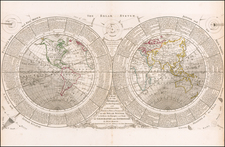
Northwest Passage Discovered!
Striking large format world map, published by Cruchley in 1858.
Among the most interesting elements of the map is the clear illustration of the recently discovered Northwest Passage.
Centered on the Pacific Ocean, the map identifies a number of newly discovered areas in the Antarctic. The map is noteworthy for the many explorers routes shown on the map, too many to name.
Robert McClure's Arctic Expedition (1850-1854): McClure's expedition aboard HMS Investigator is recognized for making the first discovery of the Northwest Passage. Beginning in 1850, McClure entered the passage from the Pacific side but became trapped in the ice. In 1853, after a long period of entrapment, McClure and his crew were rescued by a sledge party from HMS Resolute, which was part of Sir Edward Belcher's expedition coming from the east. This event effectively marked the first time that a passage had been traced, albeit partially over ice, from the Pacific to the Atlantic.
The Expeditions of Sir Edward Belcher (1852-1854): In 1852, the British Admiralty dispatched an expedition under the command of Sir Edward Belcher. Comprising five ships - HMS Assistance, Resolute, Pioneer, Intrepid, and North Star - the expedition aimed to rescue Sir John Franklin's lost expedition and to further explore the Canadian Arctic. Despite extensive exploration, the expedition failed to find Franklin and ultimately resulted in the abandonment of four ships in the ice.
While McClure did not complete a single, continuous sea voyage through the passage, his expedition was the first to connect the dots between the Atlantic and Pacific Oceans across the Arctic. The full navigability of the Northwest Passage, however, would not be conclusively demonstrated until Roald Amundsen's successful voyage from 1903 to 1906.
Rarity
This is the first time we have seen this map.
![(Apollo 14 - Recovery Tracking Manuscript) [Post lunar landing recovery map and related ephemera from aboard USS New Orleans including NASA issued Apollo 14 insignia patch] Apollo Mission Plotting Chart (AMP) 4th Apollo Edition, January 1969.](https://storage.googleapis.com/raremaps/img/small/76611.jpg)
![[ Early Infographic Chart ] Geography Epitomiz'd. Of The Stars And Planets. Of The Sun And Moon. Of the Air and Meteors. The Terms of Geography Explain'd.](https://storage.googleapis.com/raremaps/img/small/101679.jpg)