|
||

|

|
|

|
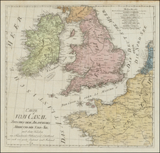
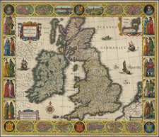
Decorative map of ancient Britain, with an elaborate title cartouche. Issued as part of Zatta's Atlante Novissimo, one of the last great decorative atlases.
The map offers a look into the ancient histories of Great Britain and Ireland. In its titling alone, the map evokes the historical epithets of these islands—Albion for Britain and Ivernia for Ireland—names steeped in antiquity and imbued with complex cultural meanings.
The term "Albion," a name encountered in Classical literature, notably by ancient Greek and Roman geographers, offers intriguing perspectives. It is a term often associated with the white cliffs of Dover, the first sight that greeted travelers crossing the English Channel. Etymologically, "Albion" is closely linked to the Latin word 'albus,' meaning 'white,' a poetic allusion that taps into geological, geographical, and cultural narratives. Within ancient Roman contexts, Albion was perceived as a land at the edges of the world, a place fraught with challenges and enigmatic peoples, like the Picts and the Celts. Latin and Greek accounts often presented it as an almost mythical land, shrouded in mists and rife with mystical qualities, further emphasizing the island's exoticism and otherworldliness.
Similarly, the term "Ivernia" calls forth ancient perspectives on Ireland. The name itself can be traced to classical references, perhaps most notably in Ptolemy's "Geographia," where he refers to Ireland as "Iouernia." While the etymology remains a subject of scholarly debate, the term conjures Ireland's ancient identity as a land of enigmatic tribes and mystical landscapes. The country has been frequently cited in Celtic mythology and folklore, creating an image of a territory on the cusp between the real and the mythical.
The toponyms and nomenclature found on the map extend far beyond the broad appellations of Albion and Ivernia. They include ancient Roman towns, forts, and settlements, many of which carry names that have evolved but can still be traced in the modern landscape. Places like Londinium (London), Eboracum (York), or Camulodunum (Colchester) in Britannia Major, and Hibernian locations like Eblana (Dublin), encapsulate within them the layers of Roman, Celtic, and even earlier histories. The names are linguistic relics, speaking to successive eras of conquest, assimilation, and resistance. They serve as gateways into multifaceted pasts that include Roman colonization, Celtic traditions, and even earlier prehistoric communities.
Moreover, the map's portrayal of the hydrography—the Thames, the Severn, the Shannon—also engages deeply with ancient history. Many of these river names have etymological roots that are deeply Celtic, predating Roman arrival and persisting through millennia.
Antonio Zatta (fl. 1757-1797) was a prominent Italian editor, cartographer, and publisher. Little is known about his life beyond his many surviving published works. It is possible that he was born as early as 1722 and lived as late as 1804. He lived in Venice and his work flourished between 1757 and 1797. He is best known for his atlas, Atlante Novissimo (1779-1785), and for his prolific output of prints and books that were both precisely made and aesthetically pleasing. Zatta clearly had a large network from which to draw information; this is how he was able to publish the first glimpse of the islands visited by Captain Cook in the Atlante Novissimo. Zatta also published books of plays and architecture.