


|
||

|

|
|

|
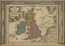
Finely colored example of the Blaeu's map of the British Isles.
The map includes a title cartouche, compass rose, sailing ships, sea monster and a portrait of King James I.
A marvelous carte-a-figures map with vertical margins of costumed figures and six oval vignettes of the principal cities along the upper horizontal margin.
After purchasing Jodocus Hondius' (II) copperplate circa 1629 and replacing the late mapmaker's name with his own, Blaeu published this map in three states, according to Gunther Schilder.
State 1 (1630): With decorative borders and without verso text. Available as a separately-issued map and in Blaeu's 1630 Appendix.
State 2 (1631): With decorative borders and verso text. Appeared in some copies of the first version of Blaeu's 1631 Appendix.
State 3 (1631 and after): Without decorative border and with verso text. Appeared in some copies of the first version of Blaeu's 1631 Appendix and most of the successive editions.
Schilder, Gunther. Monumenta Cartographica Neerlandica VI.
Willem Janszoon Blaeu (1571-1638) was a prominent Dutch geographer and publisher. Born the son of a herring merchant, Blaeu chose not fish but mathematics and astronomy for his focus. He studied with the famous Danish astronomer Tycho Brahe, with whom he honed his instrument and globe making skills. Blaeu set up shop in Amsterdam, where he sold instruments and globes, published maps, and edited the works of intellectuals like Descartes and Hugo Grotius. In 1635, he released his atlas, Theatrum Orbis Terrarum, sive, Atlas novus.
Willem died in 1638. He had two sons, Cornelis (1610-1648) and Joan (1596-1673). Joan trained as a lawyer, but joined his father’s business rather than practice. After his father’s death, the brothers took over their father’s shop and Joan took on his work as hydrographer to the Dutch East India Company. Later in life, Joan would modify and greatly expand his father’s Atlas novus, eventually releasing his masterpiece, the Atlas maior, between 1662 and 1672.
![[Jamestown, Saint Helena] Plan de la Forteresse et Bourg, De L'Isle De St. Helene](https://storage.googleapis.com/raremaps/img/small/77017.jpg)
