|
||

|

|
|

|
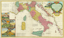
Exceedingly Rare First Dutch Sea Chart of the Italian Mediterranean Coastline, From the First Sea Atlas of the Mediterranean
Very rare original antique sea chart of the central Italian Coastline covering parts of the provinces of Tuscany, Lazio, Caserta and Naples, extending from the the Amalfi Coast and the Bay of Naples in the south to to the Giglio Porto. The islands shown on the map include Capri, Ischia, Ponza, Palmarola, Zannone, Cala Spalmatoio and Ventotene.
The map appeared in William Barentsz's important Caertboeck Vande Midlandtsche Zee, first published in Amsterdam in 1595.
This map represents the earliest printed navigational chart of this area, drawing on previous Italian portolan charts. Highly decorated in a manner that shows the cooperation between Barentsz, Claesz, and Petrus Plancius, another important Low Countries cartographer, the map is replete with numerous sailing ships and sea monsters. Two compass roses appear with associated rhumb lines. The map also includes two cartouches, one with the title and one with a scale bar.
The map is extremely decorative reflecting Plancius's decorative influence on Barentsz. Containing three compass roses, the same number of cartouches, six sailing vessels, and four sea monsters, this really is a marvelous map.
This map appeared in the very rare French edition of the Caertboeck.
Caertboeck vande Midlandtsche Zee
Barentsz's Caertboeck, published by Claudius Claesz, represents the first printed navigational atlas of the Mediterranean. Containing nine charts of regions of the Mediterranean, as well as one Portolan chart of the whole sea, the atlas was based on a number of early sources including Italian, Spanish, and Portuguese portolans as well as the travels and accumulated knowledge of Barentsz and other Dutch pilots. The atlas represented a stark contrast to earlier Dutch navigational atlases, which relied primarily on coastal views and only the most basic maps.
This atlas was first printed in 1595 as its principal cartographer, Barentsz, was embarking on his ill-fated voyages that attempted to find a northern passage to China. The atlas was printed a number of times later, with the last edition in appearing 1654 after the plates passed to Jansson.
Note on the Compass Roses
The compass roses show declinations that vary by just under six degrees. One is for a "ghemenye" compass, used in northern European waters, and is set for the magnetic variation in Northern European waters. The other is made for Italian compasses, set for Mediterranean waters and shows the variation for that part of the world. These two compasses simplified navigation, so that sailors did not have to constantly correct for variations.
It is very unusual to see both compasses on the same map.
Rarity
This map is very rare. It is the first time we have offered it for sale (although we have previously had a much later reprint), and we find no prior evidence of it having been on the market.
This is the only example we are aware of to appear on the market in the past 30 years, having traded once in the early 2000s and once in 2023.
![[Ostia / Lazio / Rome] Der Statt Ostien und umbligender Landtschafft : gelegenheit und abcontrafactur](https://storage.googleapis.com/raremaps/img/small/75245.jpg)
![[ France and Low Countries ] Totius galliae descriptio, cum parte Angliae, Germaniae, Flandriae, Brabantiae, Italiae, Romam usque](https://storage.googleapis.com/raremaps/img/small/74214.jpg)