


|
||

|

|
|

|
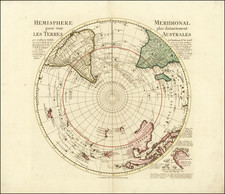
Charting the Southern Hemisphere to commemorate Lozier Bouvet's 1738-9 voyage.
Fine map of the southern hemisphere, meticulously detailing Lozier Bouvet's voyage of exploration.
Based upon the work of famed French mapmaker Guillaume De L'Isle, the map includes text in French and Dutch describing Lozier's explorations, with tracks meticulously charted on the map.
Overall, there are two points of interest that a reader would notice right away. First, the hemispheric, circumpolar projection has the opposite effect of the more-common Mercator projection. The Mercator projection inflates land masses at the southern pole while showing regions closer to the Equator in their correct proportion. This projection, conversely, shows the Polar regions correctly and distorts Equatorial areas.
The other detail of note is the presence of the vast empty spaces at the pole. These blank spaces were a major innovation by the original mapmaker, Guillaume De L'Isle. Unlike many of his contemporaries, De L'Isle preferred blank spaces to conjecture or decorative embellishment. If he did not know the shape of a coast, he left it out or at least marked it with a dotted line. This approach is emblematic of the more scientific approach to mapmaking adopted in the eighteenth century.
Southern Hemisphere
This fascinating map captures the entire Southern Hemisphere from a polar projection. This rare variant example includes an additional text panel describing Lozier Bouvet's voyage, added to the right side of the map. The cartography features many of the contemporary myths and anomalies associated with the Antipodes. The map features excellent projections of Australia and New Zealand, along with a number of early routes of exploration from the 16th, 17th and 18th Centuries, including Tasman, Halley, Damiper, Magellan, Le Maire, Mendana and others.
The "port", allegedly discovered by Sir Francis Drake, otherwise known as Drake's Island, in 1577, lies to the southwest of Cape Horn. Some of the more notable features are Edmund Halley's sighting of Antarctic ice; Bouvet's large Cap de la Circoncision; Carpentaria attached to New Guinea; Tasman's route, along with a depiction of Tasmania as per Tasman, distinctly separate from Australia.
Emphasized on the map (heightened in orange) is the route of the 1738-9 voyage of Jean-Baptiste Charles Bouvet de Lozier (1705-86), commanding the ships Aigle and Marie, undertaken at the behest of the French East India Company. Bouvet's mandate was to find the apocryphal great southern continent. The text mentions Bouvet's discovery of icebergs between two and three hundred feet high and half a league to two or three leagues in circumference. On January 1, 1739, Bouvet encountered an icy promontory, which he named Cap de la Circoncision, at 54° South, below Africa, supposedly located next to one of the openings of his polar sea, where he had recorded his many great icebergs. An inset in the lower right of the map details this discovery.
Importantly, this was the first time land had been spotted beyond the 50th parallel South in the Eastern Atlantic. Bouvet, spotted Cap Circoncision, but severe fog and ice ensured that he was unable to explore the area further, and thus he was unaware that the landmass was part of an island, and not a southern continent. Bouvet lost sight of the cape and was unable to relocate it in the days that followed. For many decades after this map was printed, it remained a mystery as to the true nature of this discovery. Bouvet's plotting of his course was inaccurate, and in spite of several attempts, the cape was not encountered again until 1808, when it was proven to be an island. Named Bouvet Island, it is one of the World's most isolated points of land, very distant from both Africa and Antarctica, and is today administered by Norway.
Johannes Covens (1697-1774) was a Dutch geographic publisher based in Amsterdam. He is best known for his collaboration with fellow publisher Cornelis Mortier (1699-1783). Pierre Mortier the Elder (1661-1711) had obtained a privilege in 1690 to distribute the works of French geographers in the Netherlands. After his widow continued the business for several years, Cornelis took over in 1719.
In 1721, Mortier forged a partnership with Covens, who had recently married Cornelis’ sister. They published under the joint name of Covens & Mortier. In 1774, upon the death of his father, Johannes Covens II (1722-1794) took over his father’s share. In 1778, the company changed its name to J. Covens & Zoon, or J. Covens & son.
Covens II’s son, Cornelis (1764-1825), later inherited the business and brought Petrus Mortier IV back into the fold. Petrus was the great-grandson of Petrus Mortier I. From 1794, the business was called Mortier, Covens & Zoon, or Mortier, Covens, & Son.
The business specialized in publishing French geographers including Deslisle, Jaillot, and Sanson. They also published atlases, for example a 1725 reissue of Frederik de Wit’s Atlas Major and an atlas, with additions, from the works of Guillaume Delisle. There were also Covens & Mortier pocket atlases and town atlases. The company profited from acquiring plates from other geographers as well. For example, the purchased Pieter van der Aa’s plates in 1730. Finally, they also compiled a few maps in house. At their height, they had the largest collection of geographic prints ever assembled in Amsterdam.
Pierre, or Pieter, Mortier (1661-1711) was a Dutch engraver, son of a French refugee. He was born in Leiden. In 1690 he was granted a privilege to publish French maps in Dutch lands. In 1693 he released the first and accompanying volume of the Neptune Francois. The third followed in 1700. His son, Cornelis (1699-1783), would partner with Johannes Covens I, creating one of the most important map publishing companies of the eighteenth century.
![Russiae et Novae Zemlae Maritimae [Maritime Russia and Novaya Zemlya.]](https://storage.googleapis.com/raremaps/img/small/92722.jpg)