


|
||

|

|
|

|
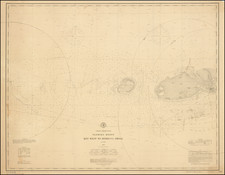
This air navigation chart, prepared in Washington, D.C. in December 1944 and published in 1945, presents a comprehensive depiction of South Florida, centered around Lake Okeechobee. Noted as an "Advance Radar Edition" and marked "Subject to Correction," this map was created during an era of significant development in radar technology, emphasizing its relevance to aeronautical and geodetic endeavors.
The 1940s were marked by technological advancements, especially in the fields of radar and aeronautics. This map, bearing indications of its relevance to radar, was created to cater to these developments. It was prepared under the guidance of the Commanding General, Army Air Forces, for the Aeronautical Chart Service, which underscores its importance in aerial navigation. The delineation of lines representing equal magnetic variation for 1944, along with the aeronautical information updated to August 1945, indicates its utility in facilitating precise navigation.

![[ Florida Indians ] Ceremonia a Saturioua in expeditionem adversus hostes profecturo, observatae. XI](https://storage.googleapis.com/raremaps/img/small/97616.jpg)