


|
||

|

|
|

|
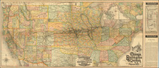
Colton's Railroad Map Intermediate Size of the United States, reduced from the six-sheet "Colton's Railroad & Commercial Map of the United States," was produced by G.W. & C.B. Colton in New York in 1881. This map offers a detailed depiction of the United States' railroad network during the late 19th century, extending from the East Coast to the regions just before the Rocky Mountains. It illustrates numerous early railroads, their respective stations, and the comprehensive network that extended from the Midwest into the Plains, highlighting the pattern and density of rail lines.
The 19th century was a time of significant growth and transformation for the United States, with railroads playing a central role. The railroad system linked previously isolated communities, facilitated the movement of goods and people, and played a pivotal role in the nation's economic and territorial expansion. By 1881, the Midwest had emerged as a hub of industry and commerce, and the rail lines extending from it to the Plains underscored the westward momentum of settlement and development.
The map also features insets, notably one detailing "Plan of New Brunswick and Nova Scotia," and another "The Southern Portion of Texas." The inclusion of New Brunswick and Nova Scotia indicates the interconnectedness of transportation and trade routes between the United States and Canada.
Rarity and Editions
The Colton firm experimented a lot with this map, reconfiguring the title and insets in practically every edition.
OCLC locates the 1870, 1872, and 1881 editions of the map. We have previously sold an 1876 edition.
OCLC's record for the 1881 lists a single example, at the Newberry Library.
G. W. & C. B. Colton was a prominent family firm of mapmakers who were leaders in the American map trade in the nineteenth century. The business was founded by Joseph Hutchins Colton (1800-1893) who bought copyrights to existing maps and oversaw their production. By the 1850s, their output had expanded to include original maps, guidebooks, atlases, and railroad maps. Joseph was succeeded by his sons, George Woolworth (1827-1901) and Charles B. Colton (1831-1916). The firm was renamed G. W. & C. B. Colton as a result. George is thought responsible for their best-known work, the General Atlas, originally published under that title in 1857. In 1898, the brothers merged their business and the firm became Colton, Ohman, & Co., which operated until 1901, when August R. Ohman took on the business alone and dropped the Colton name.
![Trails: [1595-1945]: Land, Sea, and Air of The American Adventure Series](https://storage.googleapis.com/raremaps/img/small/70672.jpg)

![The Travellers Guide or Map of The Roads, Canals & Rail Roads of the United States, With the distances from Place to Place By H.S. Tanner 1845 [with] The American Traveller, or Tourists' and Emigrants' Guide Through The United States . . . .](https://storage.googleapis.com/raremaps/img/small/99038.jpg)
![[Shows Republic of Texas] United States and Texas](https://storage.googleapis.com/raremaps/img/small/101139.jpg)
![(Puzzle Map) Mapa de America Del Norte y Central Razas y Fauna Del Continente [Map of North and Central America Races and Animals of the Continent]](https://storage.googleapis.com/raremaps/img/small/91115.jpg)