|
||

|

|
|

|
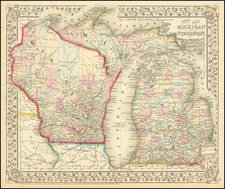
Detailed map of the city of Detroit, hand colored by wards.
Shows the Michigan Central RR and Depot, Detroit & Milwaukee RR and Depot, Michigan Exchange, Biddle House, Post Office, Masonic Hall, Board of Trade, Water Works, Harper Hospital, Crawford Park, Grand Trunk RR, Monroe & Toledo RR, City Hall, Music Hall, Opera House and a number of other early features.
The second state of the first map of Detroit to appear in a commercial atlas.
Samuel Augustus Mitchell Jr. inherited the Mitchell Company from his father in 1860. For over thirty years, the company had specialized in the production of school atlases and wall maps of America. They were one of the pioneers on engraving on steel plates. In 1860, Samuel Jr. released the New General Atlas, which had been compiled in house and replaced a previous atlas by Tanner. The elder Mitchell died in 1868 and Samuel Jr. continued the business until the 1890s. At its height, the Mitchell Company employed 250 people and sold 400,000 publications annually.
![The State of Ohio with part of Upper Canada, &c. [and Part of Michigan Territory within Ohio]](https://storage.googleapis.com/raremaps/img/small/102945.jpg)
![[ First map of Michigan Territory published in Europe ] Carte Geographique, Statistique et Historique De Michigan](https://storage.googleapis.com/raremaps/img/small/99266.jpg)