


|
||

|

|
|

|
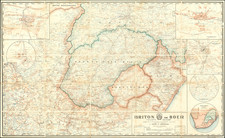
Scarce pictorial map of the environs of Pretoria, South Africa, published in Durban in 1955.
The map of Pretoria from 1955 presents a structured layout of the city, showing neighborhoods, streets, landmarks, and zones of administrative importance. The map's color scheme differentiates urban development from natural landscapes, with significant buildings rendered along the map's upper edge, indicative of their stature within the city's framework. The peripheral areas suggest a blend of agricultural and less densely populated regions.
The verso side of the map, rich with images and explanatory text, serves as an informative guide, detailing the historical significance of various sites and figures pertinent to Pretoria's heritage.
During the mid-20th century, Pretoria functioned as the administrative capital of South Africa. This period was characterized by the entrenchment of apartheid, initiated in 1948, which imposed racial segregation and set the stage for the city's subsequent historical developments. As the seat of government, Pretoria was central to the enactment of apartheid laws, and it also became a focal point for political resistance against this regime.
The city's architecture, particularly the Union Buildings, played a role in the administrative operations of apartheid, and these edifices remain as historical markers of this era. The map, as a document, is therefore a reflection of Pretoria's urban landscape during a time of significant political tension and societal division.
![[South Africa / Algoa Bay, Mossel Bay / Vleesbai ] The Bay of Algoa on the South Coast of Africa . . . | Plan of Mossel Bay on the South Coast of Africa . . . | Plan of Flesh Bay or Bay of St. Bras on The South Coast of Africa](https://storage.googleapis.com/raremaps/img/small/85695.jpg)
![Egypt and Barca [with] Abissina and Nubia [with] Congo. Angola. Cafres. Monoemugi. Monomotapa. Zanguebar & Madagascar](https://storage.googleapis.com/raremaps/img/small/78890.jpg)
![[With Photos of an Early Owner!] Troye's Map of the Transvaal or S.A. Republic](https://storage.googleapis.com/raremaps/img/small/87453.jpg)