|
||

|

|
|

|
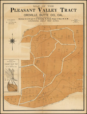
Stock# 97483
Description
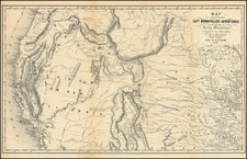
Aeronautical survey chart published in 1952 in 1:1,000,000 scale featuring Mt. Whitney, showing topographical data and including all or parts of the Norman Mesa Range, Pyramid and Winnemucca Lakes, Lake Tahoe, San Joaquin Valley, Death Valley, the Las Vegas Bombing and Gunnery Range, and the San Francisco and Los Angeles Air Defense Identification Zones.
Condition Description
Minor marginal soiling.
![(19th-Century California Photograph) [Bird's-eye photograph view of Grass Valley, Cal. 1876]](https://storage.googleapis.com/raremaps/img/small/95393.jpg)