


|
||

|

|
|

|
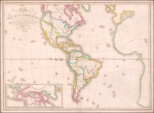
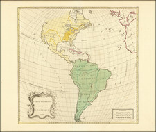
An impressive 1744 publication by Emanuel Bowen, "A New General Map of America" offers a distinctive perspective on the geography of North and South America during the mid-18th century, underscored by the notable absence of San Diego and San Francisco (although the latter perhaps represented by "Drakes Port"), and the inclusion of the speculative Straits of Anian.
During this time, the intricacies of America's geography were still being discovered, leading to the creation of maps that were as much a work of conjecture as they were a document of known facts. Bowen's map serves as a testament to this epoch of exploration, featuring several imaginative details such as the "Parts Undiscovered" in the Northwestern part of North America and the "supposed Straits of Anian." Bowen, a prominent English mapmaker and engraver, was known for his careful amalgamation of available geographic and topographic data, making his maps valuable resources for understanding historical views of world geography.
Bowen’s detailing of locations such as Cape Mendocino, New Albion, Drake's Port, Monterrey, and the Channel Islands provides insight into the geographic knowledge and misconceptions of the time. The absence of San Diego and San Francisco, cities that would later become pivotal locations in American history, highlights the evolving understanding of the continent’s western coast.
This map, drawn from various 'accurate particular Maps & Charts', embodies the fluid and somewhat nascent state of cartography in the 18th century. Not merely a representation of the known world, it is also a window into the uncertainties, hypotheses, and aspirations of an era defined by discovery and exploration. It serves as an evocative artifact of the ceaseless human quest for knowledge, capturing a moment in time when the geography of the Americas was a canvas partially filled, with vast areas awaiting the explorer's touch.
Emanuel Bowen (1694?-1767) was a British engraver and print seller. He was most well-known for his atlases and county maps. Although he died in poverty, he was widely acknowledged for his expertise and was appointed as mapmaker to both George II of England and Louis XV of France. His business was carried on by his son, Thomas Bowen. He also trained many apprentices, two of whom became prominent mapmakers, Thomas Kitchin and Thomas Jeffreys.
![La America Dispuesta segun las ultimas y nuevas observationes de las Accademias, y de Paris, y de Londres [Bay or Sea of the West--Very Rare]](https://storage.googleapis.com/raremaps/img/small/75936.jpg)