|
||

|

|
|

|
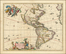
Rare Spanish Language Map of The Americas with the Sea of the West
Fine impression of this rare map of America, published by Spanish cartographer Pedro Gendrón in London.
The map shows both American continents, from Hudson’s Bay to Tierra del Fuego, on a curved projection. Much of Western Africa and Europe are included as well.
The Mississippi watershed fans across North America, while South America is dominated by the Amazon and the Rio de la Plata basins.
Although produced in London, the map’s nomenclature is in Spanish and contains several details important to the Spanish Empire. There are dotted lines showing trade routes, such as the “Camino de la Habana.” There is also the Line of Demarcation, a boundary drawn by a 1494 papal bull to separate the world into Spanish and Portuguese imperial spheres.
Islands dot the Atlantic and Pacific oceans. Some were relatively new to European maps. For example, Isla de Pascua, or Easter Island, was only encountered by Europeans several decades before the map was published. Now known by its Indigenous name, Rapa Nui, the island was settled between 300 and 1200 CE. The Dutch navigator Jacob Roggeveen visited on Easter Sunday, 1722, making he and his crew the first Westerners to marvel at the famed moai.
Some of these islands were only hypotheses or fantasies, however. For example, a small unfinished coastline off the coast of Chile marks land seen by David Ingles in 1687. This refers to an island purportedly sighted by the English buccaneer Edward Davis in that year and reported by the pirate-authors Lionel Wafer and William Dampier around the turn of the eighteenth century. Whereas the island became a fixture on maps, it was later proven to be a mis-identification of islands further east, due most likely to an editing error which placed the island 500 leagues, rather than 500 miles, from the Chilean coast.
Other islands were both mythical and real. The Solomon Islands were settled as early as 30,000 BCE. Álvaro de Mendaña led an expedition that landed there in 1568. He returned in 1595, intending to colonize the islands, but could not retrace their route. On that voyage was a navigator, Pedro Fernandez de Quiros; he was convinced that the Pacific housed a paradisiacal continent, of which the Solomons were likely a part. He sought this Eden on another voyage, in 1605, landing in Vanuatu. The precise location of the Solomons remained a mystery until the late-eighteenth century, making it a tantalizing geographic chimera for hundreds of years.
The Sea of the West and Admiral de la Fonte
Prominently displayed on this map is a large inland sea in the Pacific Northwest of North America. Many European maps in the eighteenth century depict such a sea, hundreds of miles in diameter, with a small inlet to the Pacific and even some interior islands. The origins of this mythic body of water can be traced to several different sources and are tied to the search for a Northwest Passage. Like many cartographic myths, the Sea of the West persisted for decades, even in the face of strong evidence pointing to its non-existence.
The more southerly entrance to the sea on this map is named for an Aguilar. Martin Aguilar, a Spanish captain, sailed with Sebastian Vizcaino on a reconnaissance expedition up the California coast in 1602-3. Aguilar, commanding the Tres Reyes, was blown off course, to the north. When the seas calmed, Aguilar reported that he had found the mouth of a large river. Eighteenth-century geographers later conjectured that the river was the entrance to the Sea of the West.
The other, more northerly entrance, is named for a Fuca, and the sea itself is said to have been discovered by him. Juan de la Fuca is the Castilianized name of Greek navigator Ioánnis Fokás (Phokás). Little archival evidence survives of Fuca’s career, but a chance meeting with an English financier, Michael Lok, in Venice in 1596 gave birth to rumors of Fuca’s voyages in the Pacific. Fuca reported that he had been sent north from New Spain twice in 1592 in search of the Strait of Anian. The Spanish Crown failed to reward Fuca’s discovery of an opening in the coast at roughly 47° N latitude and Fuca left the Spanish service embittered. His story lived on in Lok’s letters and eventually was published in Samuel Purchas’ travel collection of 1625. On many eighteenth-century maps, Fuca’s Strait is linked with a River or Sea of the West. In 1787, the present-day Juan de Fuca Strait was named by the wife of naval explorer Charles William Barkley, making permanent a label that had previously just been hopeful guesswork.
A peninsula near to the Sea of the West says it was found by an “Admiral de la Fuente.” Admiral Fonte supposedly sailed to the area in the mid-seventeenth century. The first mention of Fonte appears in two letters published in London in 1708 in two issues of The Monthly Miscellany or Memoirs for the Curious. The Fonte letters had been reprinted by Arthur Dobbs in his 1744 An Account of the Countries adjoining Hudson's Bay and were mentioned in other travel accounts.
The letters recounted that Fonte had found an inlet near 53°N which led to a series of lakes. While sailing northeast, Fonte eventually met with a Boston merchant ship, commanded by a Captain Shapley. One of Fonte's captains, separated from the Admiral, reported he had found no strait between the Pacific and the Davis Straits, yet had reached 79°N, helped by local indigenous peoples. This story, with its suggestion of water passages connecting the Pacific Northwest with the east, inspired hope in some and doubt in others in the mid-eighteenth century. A few, like Irish mapmaker John Green, thought the entire story a farce. Many others thought the information conformed neatly to other recent discoveries and included Fonte on their maps.
The Sea of the West was speculated to exist by Guillaume De L’Isle, France foremost theoretical geographer, around the turn of the eighteenth century. It first appeared in print on maps published by Jean Baptiste Nolin ca. 1700, but it quickly disappeared thereafter.
The re-introduction of the sea in the mid-eighteenth century was the result of De L’Isle’s son-in-law, Philippe Buache’s review of his father-in-law’s papers. Although De L’Isle never published a map showing the sea, he had postulated that it could exist, and that it might connect to a Northwest Passage through New France, not through English territory farther north. Nolin had plagiarized the idea from Guillaume, as the latter testified when suing the former for plagiarism. He said, the Sea of the West “was one of my discoveries. But since it is not always appropriate to publish what one knows or what one thinks one knows, I have not had this sea engraved on the works that I made public, not wanting foreigners to profit from this discovery” (as quoted in Pedley, The Commerce of Cartography, 109).
The sea was a major part of Buache and Joseph-Nicholas Delisle’s maps of the North Pacific published from the early 1750s. While controversial, the features of those maps were quickly copied by other mapmakers, including the Sea of the West. The inland body of water lingered on maps until the later-eighteenth century, as seen here.
Rarity
This map is rare on the market, especially in full original color.
![[ Pacific Ocean and America -- The West Indies ] Descripcion De Las Yndias Ocidentales](https://storage.googleapis.com/raremaps/img/small/95683.jpg)

![[ Prague Travel Agency Poster ] 1tes Prager Conces Reise-Bureau D. Schick & Rosenbaum Prag. Spedition: Wenzelsplatz No. 15 (Round-Trip Tickets & Ship Tickets to all of America . . . )](https://storage.googleapis.com/raremaps/img/small/96465.jpg)