|
||

|

|
|

|
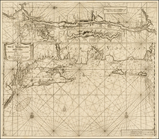
The Island of Manhattan (Mannahatin) at the Time of its Discovery, authored by Townsend MacCoun, presents a comprehensive portrayal of Manhattan's early geography in 1609. It systematically delineates its elevations, water-courses, marshes, and shorelines. Rooted in the early colonial surveys from surveyors like Ratzer, Montresor, Knypthausen, Bradford, Duyckinck, and the 1867 "water" survey by Genl. E. L. Viele, this map offers a clear juxtaposition of Manhattan's original topography with its 1909 streets and shorelines.
This map provides an objective window into Manhattan's physical characteristics three centuries prior, showcasing its initial condition before substantial European settlement and urban development. The overlay of the 1609 landscape with 1909 infrastructure serves as a comparative tool, elucidating the island's steady progression over three centuries.
Mac Coun's use of early colonial surveys provides a foundation of accuracy for this depiction, while the inclusion of identified Indian nomenclature emphasizes the historical significance of indigenous presence and influence on the land.