|
||

|

|
|

|
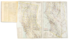
Rare 1920s Sanborn Atlas of Brawley, California
Brawley Imperial Co. Cal., a fire insurance atlas produced by the Sanborn Company in 1922 with subsequent updates in 1930, provides a detailed representation of the built environment of Brawley, a town in California's Imperial County that didn't exist before 1906. The atlas, spanning 20 sheets including its index, showcases essential information about the city’s infrastructure, water facilities, and fire prevention resources, making it a valuable document for understanding urban planning in early 20th-century rural Southern California.
Brawley, situated in Imperial County, underwent rapid growth and urbanization in the 1920s, largely spurred by expansive agricultural development enabled by irrigation from the Colorado River. The present atlas, with extensive pasted updates (maintained by a Sanborn Co. "paster"), attests to the massive changes underway in Brawley between 1922 and 1930. Notably, several large scale Japanese-owned fruit and vegetable packing concerns are indicated on the maps. Some of the Japanese families of Brawley were later forced into internment camps during World World II.
As cities such as Brawley expanded, the need for detailed urban planning grew paramount and fire insurance maps such those comprising the present atlas played a vital role. These documents not only aided insurance underwriters in assessing fire risks for various properties, they guided urban development, as local governments were often subscribers to Sanborn's mapping services. This Brawley atlas, with its layers of detail for the years 1922-1930, records the city's built environment to a detail level not available elsewhere, revealing, for example, a segregated public school system (with Mexican and African-American school children in designated schools). For all of the above, such a group of maps stand today as vital primary sources for understanding the urban and community fabric of places like Brawley.
Here follows a selection of notable structures shown in the atlas:
- Imperial Mill & Ginning Co.
- J. Katerkaru Co. Vegetable Packing (i.e. Katekaru, a Japanese-owned vegetable shipper)
- K. Asamen Vegetable & Produce Shipping
- Iwata & Co. Fruit & Vegetable & Shipping
- Brawley Union High School
- Hotel St. Regis
- Municipal Light & Water Works
- East Side Public School (Mexican and Negro)
- Negro School
- Numerous Mexican and Negro Shacks
- American Fruit Growers Inc.
- Imperial Ice & Development Co.'s Ice Plant No. 3
- Tourist Inn
- Planters Hotel
The water infrastructure, described extensively, portrays a municipality in possession of a sophisticated system. Featuring both a pump and gravity system, it encompasses facilities such as a pumping plant, settling basins, and reservoirs with a total capacity of 12,000,000 gallons. The distribution network's capacity, with its variety of main sizes and hydrants, underscores the city's commitment to ensuring adequate water supply in emergencies.
Rarity
The Brawley Sanborn atlas is very rare in the market. No examples of any edition located in OCLC. The Library of Congress has digitized editions of 1910, 1911, 1916, and a 1922 (updated to 1962), but not the present 1922 iteration updated to 1930.
The Sanborn Map Company, founded in the 1860s by Daniel Alfred Sanborn, is a renowned cartographic institution primarily recognized for its unparalleled fire insurance atlases. These atlases emerged as indispensable tools during the late 19th and early 20th centuries, portraying the evolution of urban America with unprecedented detail and precision. Charting both burgeoning metropolises and smaller municipalities, Sanborn's fire insurance maps provide a unique and illuminating perspective on the physical, economic, and social transformation of the nation during a period of intense urbanization and industrialization.
During the latter half of the 19th century, the United States witnessed an acceleration in urban growth. This shift from rural to urban living, bolstered by the advent of the Industrial Revolution, generated densely populated areas with a diverse array of architectural styles, materials, and infrastructure. In this context, the need for comprehensive maps that could illustrate the specifics of the built urban fabric became paramount, especially for insurance companies seeking to assess the risks associated with insuring individual properties. The Sanborn Map Company responded to this demand, creating elaborate maps that identified building materials, the purpose of structures, and even features like fire walls and sprinkler systems.
A standout feature of Sanborn's maps was their color-coding system, which allowed for a swift and clear differentiation between building materials—whether wood, brick, iron, or otherwise. This system, paired with the company's legends -- detailing everything from the width of streets to the locations of hydrants -- made these atlases an invaluable resource for insurance underwriters. By the turn of the 20th century, Sanborn maps covered thousands of cities and towns across the United States.
Beyond their utility to the insurance industry, the atlases produced by the Sanborn Map Company have, over time, become a treasured resource for historians, urban planners, preservationists, and environmental researchers. These maps have also been pivotal in brownfield research, shedding light on past industrial activities and potential contamination sites. They offer a window into the past, capturing the architectural, infrastructural, and environmental trends of various eras, and revealing the intricacies of a city's development. The very design of streets, the evolution of residential and commercial areas, and the rise and decline of certain industries can be traced through these maps.
Around 1960, Warren Buffett, then a burgeoning value investor, took a significant position in Sanborn Map Co., sinking 35% of his partnership's money into the company. Buffett was drawn to Sanborn's extensive map business, which he described as a virtual monopoly, as well as the company's valuable investment portfolio. While the cartographic aspect of Sanborn's business was diminishing in profitability due to technological advances introduced by competitors, Buffett recognized that the informational content of the maps had not been updated to electronic access, and was thus an undervalued asset for the company. His investment in Sanborn Map Co. is often presented as Case Study No. 1 in overviews of his value-oriented investment philosophy, which emphasized undervalued assets.
In sum, the Sanborn Map Company's fire insurance atlases are not merely maps; they are intricate tapestries of American urban history, detailing the nation's progression from the late 19th to the 20th century. Through their detailed renderings, these maps continue to serve as invaluable chronicles of the United States' urban transformation during a pivotal era.
![Le Vere Imagini et Descritioni delle Piu Nobilli Citta del Mondo [The true images and descriptions of the most noble cities in the world]](https://storage.googleapis.com/raremaps/img/small/92842.jpg)

![(Atlas of the Aegean -- Extra Illustrated!) L'Egeo redivivo o' sia chorographia dell' arcipelago, e dello stato primiero, & attuale di quell' isole. . . [The Aegean revived, or the chorography of the archipelago, and of the original and current state of those islands. . .]](https://storage.googleapis.com/raremaps/img/small/93229.jpg)