


|
||

|

|
|

|
"Waikiki Photo-Guide Map" is a promotional brochure created in 1958 by M.H. Carter and Where-Abouts Ltd. This guide provides a photographic and pictographic rendition of the islands of Hawaii, illustrating the recreational activities, industry, and points of interest throughout the island chain.
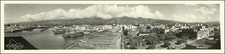
The main highlight of this brochure is an aerial photograph of Waikiki Beach with the majestic Diamond Head in the background, one of Hawaii's most famous landmarks. This ancient volcanic crater forms a dramatic backdrop for the beaches of Waikiki and is a popular hiking destination for panoramic views. Accompanying the photo of Waikiki Beach as an aerial panorama of Honolulu and its downtown.
The brochure also features a fine depiction of the other islands of Hawaii. This section includes the colloquial name of the island and pictorial illustrations showing the agricultural production, historic sights, and recreational activities present on the island. These include the monument to Captain James Cook, various resorts, and the famous Haleakala National Park. The brochure provides recommendations for interisland travel and ideal tourist locations.
Overall, this is an authentic guide to the wonders of Waikiki, offering visitors valuable tips on where to go and what to do, enhancing their Hawaiian experience. This guide is an updated brochure from Carter and Wikiwiki Whereabouts that features similar pictures and information as an earlier 1956 brochure by the same group.
![The Island of Hawaii, The Big Island of the Territory of Hawaii which became an integral part of the United States of America voluntarily and not by conquest of purchase, extends its welcome to all visitors [with] Street Map of Hilo showing points of interest (verso)](https://storage.googleapis.com/raremaps/img/small/93306.jpg)
![[Waikiki] Waikiki Photo-Guide Map](https://storage.googleapis.com/raremaps/img/small/87465.jpg)
![[Hawaii] Le Isole di Sandwich Delineate Sulle Osservazioni De. Cap. Cook . . . 1798](https://storage.googleapis.com/raremaps/img/small/91731.jpg)
![Pan Am's Hawaian Islands [ and ] Street Map of Honolulu](https://storage.googleapis.com/raremaps/img/small/99988.jpg)