|
||

|

|
|

|
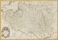
A New Map of Germany, Divided Into Its Circles, engraved by John Cary and published in London in 1799, offers an incisive look into the geopolitical intricacies of the German Empire during the twilight of the 18th century. Delineating boundaries from the Baltic and the Gulf of Dantzig in the northeast to the Low Countries in the northwest, and from the Republic of Venice in the southwest to Belgrade in the southeast, Cary's work illustrates the vast and varied territories under German influence at this pivotal juncture in European history.
The close of the 18th century marked a time of substantial flux in the European landscape. The German Empire, a complex network of territories and states, was seeing the last of its Holy Roman Empire days, soon to be dissolved in the early 19th century. Amidst the broader European backdrop of revolutionary fervor, Napoleonic ambitions, and the reconfigurations of territories, the German Empire's portrayal here captures a fleeting moment before the storms of change would redraw its maps.
John Cary's cartographic prowess is evident in his astute representation of the empire's divisions: the various circles like the Upper and Lower Rhine, Sabia, Austria, Bavaria, and Upper and Lower Saxony, among others. Notably, Cary includes the Kingdom of Bohemia, emphasizing its significant role within the Germanic sphere. These divisions are pivotal for they provide the viewer with an understanding of the regional balances and intricacies that would play a crucial role in the subsequent political negotiations and restructurings.
In totality, Cary's A New Map of Germany stands as a testament to the transitory nature of empires and the complexities of geopolitical configurations, serving as a window into a Europe on the precipice of monumental transformations.
John Cary (1755-1835) was a British cartographer and publisher best known for his clean engraving and distinct style which influenced the entire map industry. Born in Wiltshire, John was apprenticed to an engraver in London. He started his own business by 1782 and moved to several premises before settling at 86 St James’s Street in 1820.
Cary had several significant collaborations during his career. John Wallis and Cary diversified Cary’s business to include broader publishing projects. Brother William and John made globes together, while brother Francis participated in the company’s engraving work. Finally, geologist William Smith and Cary developed and sold geological maps, some of the first of their kind. The pair also produced a notable series of county maps starting in 1819. Cary’s atlases, of English counties and the world, were the standard texts of the early nineteenth century. He was appointed surveyor of roads to the General Post Office in 1794, which led to the New Itinerary, first published in 1798.
John trained his son, George, in engraving and George and his other son, John Jr., took over the business in 1821. It was then known as G. and J. Cary and continued in trade until 1850. The firm’s materials were then acquired by George Frederick Cruchley and then Gall and Inglis. By the time John died in 1835, Cary was the authoritative name in private map publishing and his business was a leader in the field throughout the first half of the nineteenth century.
![[ Bad Gastein ] Wildbad Gastein](https://storage.googleapis.com/raremaps/img/small/96453.jpg)
![[ Moravia / Eastern Czechia ] Markgrathum Maehren samt oesterreischisch Schleisien nach den Neuesten astronomischen unde andern Bestimungen . . .](https://storage.googleapis.com/raremaps/img/small/103030.jpg)