|
||

|

|
|

|
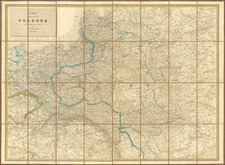
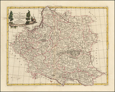
Poland Corrected from the Observations communicated to the Royal Society at London and the Royal Academy at Paris, engraved by John Senex and published in London in 1711, offers an important depiction of the Polish empire. Dedicated to St. James Hallett Kt., a citizen of London, the map's title underscores the collaboration between two prominent scientific societies of the early 18th century in its creation.
The early 18th century was a time of dynamic political and territorial shifts in Eastern Europe. Poland, as a significant player in the European landscape, had its borders and spheres of influence constantly in flux. This state of transition required accurate and updated cartographic records, both for practical navigation and geopolitical considerations. The collaboration with the Royal Society in London and the Royal Academy in Paris highlights the pan-European interest in the region and the importance of scientifically-informed mapmaking.
John Senex's engraving is a testament to the blend of art and science that defined the map-making process during this period. By referencing the "Observations" from two renowned institutions, it emphasizes the dedication to accuracy and the importance of empirical research in creating a comprehensive representation of territories. This collaboration ensured that the map was not only aesthetically pleasing but also served as a reliable guide to the complex geopolitical landscape of Poland.
States
This map represents the second state of the map, evidenced by the absence of Charles Price and John Maxwell's names from the title cartouche.
The decision to remove the names of Charles Price and John Maxwell from the title cartouche in the second state hints at the behind-the-scenes dynamics and potential disputes within the world of mapmaking. Such adjustments reflect the often-contentious relationships between cartographers, publishers, and patrons during this era, offering a window into the business of cartography in the early 18th century.
John Senex (1678-1740) was one of the foremost mapmakers in England in the early eighteenth century. He was also a surveyor, globemaker, and geographer. As a young man, he was apprenticed to Robert Clavell, a bookseller. He worked with several mapmakers over the course of his career, including Jeremiah Seller and Charles Price. In 1728, Senex was elected as a Fellow of the Royal Society, a rarity for mapmakers. The Fellowship reflects his career-long association as engraver to the Society and publisher of maps by Edmund Halley, among other luminaries. He is best known for his English Atlas (1714), which remained in print until the 1760s. After his death in 1740 his widow, Mary, carried on the business until 1755. Thereafter, his stock was acquired by William Herbert and Robert Sayer (maps) and James Ferguson (globes).
![Livoniae Provinciae Ac Eivs [with] Moscoviae Maximi Amplissimi Que Ducatus](https://storage.googleapis.com/raremaps/img/small/75324.jpg)