|
||

|

|
|

|
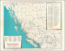
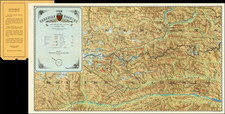
Informative Governmental Map of British Columbia
A nice view into the development of Canada and British Columbia. The map provides a detailed portrayal of two of the major cities in Okanagan Country, Kamloops and Osoyoos, as well as highlighting neighborhoods and smaller urban centers like Vernon, Cold Stream, and Armstrong. This information is presented in an intriguing way as the map uses both topographic lines and city planning grids to illustrate the general layout of the inhabited areas.
The main feature of this map is the robust range of information illustrated throughout. The legend of the map is full of details that range from the jurisdiction of mining, timber, and electoral boundaries to the location of rapids, waterfalls, and bodies of water. There are also depictions of constructed hospitals, schools, roads, and railways, with planned additions also illustrated.
A colorful depiction of this area of British Columbia during the early 1920s, before increased urban development and industrialization would change the landscape permanently. Government grants to the railway, timber, and mining industries changed the region immensely in the following years as seen by the amount of territory held by the Canadian government in the railway belt. This map would likely not be accurate a few years later simply due to the aggressive development of the area.
A copy of this map can be viewed in the University of British Columbia Online Open Collections.