


|
||

|

|
|

|
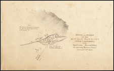
Kern County After The Breakup of Standard Oil
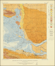
Rare cadastral wall map of Kern County, California, produced by county surveyor A. E. Stegeman and drawn by Draftsman A.D. Murray in 1918, eight years after the Supreme Court decision in Standard Oil Co. v. U.S. was decided by the Supreme Court, resulting in the breakup of the company.
This is a truly extraordinary work. Laid out townships, the map labels hundreds, perhaps thousands of land owners. The shading, intended to show topography, highlights the major oil producing fields in green (although the map legend suggests blue). In addition to the areas shown in green, major oil companies and speculators are shown throughout the map.
The map identifies paved roads, "other important roads, dedicated or traveled road and private roads.
In the area around the oil producing fields, other built infrastructure is identified, including:
- Signa Pumping Station
- Standard Oil Company Pipe Line
- Midway Gas Company Gas Pipe Line
- San Joaquin Light & Power Company Line
- Associated Pipe Line Company
- Independent Oil Producers OIl Trans. Co. Pipe Line.
Rarity
OCLC locates only three examples (California Historical Society, University of California Berkeley, and University of California Davis.
This is the only example we have seen for sale.

![(19th-Century California Photograph) [Bird's-eye photograph view of Grass Valley, Cal. 1876]](https://storage.googleapis.com/raremaps/img/small/95393.jpg)