


|
||

|

|
|

|
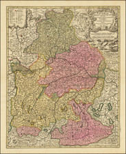
Finely colored example of this striking map and view of Nuremberg and its surrounding regions, capturing the city's importance in the 17th and 18th centuries.
The expansive geography depicted stretches from the river Regnitz's path towards Mögeldorf, passing by Fürth. The map is enriched with detailed engravings of villages, fields, trails, rivers, and woods, suggesting Nuremberg's central role in trade, culture, and politics of its time.
One of the map's standout features is the panoramic city view of Nuremberg. This representation is complemented by engraved baroque allegories, highlighting the significance of the Franconian region, the essence of Nuremberg, and the history and legacy of its land.
Nuremberg's historical context during the 17th and 18th centuries is essential for understanding the map's significance. The city suffered during the Thirty Years' War (1618-1648), experiencing both economic and demographic declines. Nuremberg tried to maintain neutrality, but the war's aftermath left a lasting impact. Despite these adversities, the Treaty of Nuremberg in 1650 acknowledged Switzerland's independence from the Holy Roman Empire, marking a significant event in the city's history.
Nuremberg was an independent imperial city, meaning it was under the Holy Roman Emperor's direct rule. However, its political influence started to wane during the 18th century, facing stiff competition from other emerging European trade hubs. Yet, the city was known for its rich culture, art, and innovation. Figures like Albrecht Dürer, a renowned painter and printmaker, hail from Nuremberg. The city's craftsmanship, especially in metalwork, made Nuremberg toys, tin figures, and watches sought-after items throughout Europe.
Local governance in Nuremberg was primarily managed by a council comprised of influential patrician families. While the Holy Roman Emperors rarely visited the city, this council oversaw its governance, ensuring its defense, infrastructure, and political stability.
Johann Baptist Homann (1663-1724) was a mapmaker who founded the famous Homann Heirs publishing company. He lived his entire life in Bavaria, particularly in Nuremberg. Initially, Johann trained to become a priest before converting to Protestantism and working as a notary.
In 1702, Johann founded a publishing house that specialized in engravings. The firm flourished, becoming the leading map publisher in Germany and an important entity in the European map market. In 1715, Johann was named Imperial Geographer to the Holy Roman Empire by Charles VI and made a member of the Prussian Academy of Sciences. Most importantly for his business, his reputation and contacts gained him imperial printing privileges which protected his publications and recommended him to customers. Johann is best known for this Grosser Atlas ueber die ganze Welt, or the Grand Atlas of the World, published in 1716.
After Johann died in 1724, the business passed to his son, Christoph (1703-1730). Upon Christoph’s early death, the company passed to subsequent heirs, with the name of the company changing to Homann Erben, or Homann Heirs. The firm continued in business until 1848.
![[ Southern Baden-Württemberg ] Derischwartz wald/in den Lonaw iren. . .](https://storage.googleapis.com/raremaps/img/small/91197.jpg)
![[ Bavarian Alps ] Deutsche Alpenpost Lindau -- Garmisch-Partenkirchen](https://storage.googleapis.com/raremaps/img/small/98061.jpg)
![(Mainz, Würzburg and Sion) Moguntia, Germaniae Metropolis, ad Rheni ripas Urbs Celeberrima, mercatorum frequentia . . . [and] Herbipolis Comuiter Wirtzburg Orientalis Franciae Metropolis [and] Sedunum, primaria & Metropolitica Valesiae urbs . . .](https://storage.googleapis.com/raremaps/img/small/55078mp2.jpg)