


|
||

|

|
|

|
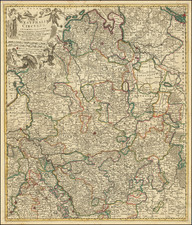
Magdeburgum Ducatus, an engraved city plan published by Matthaeus Seutter in Augsburg circa 1758, provides a detailed portrayal of Magdeburg, a prominent city and ducal seat on the Elbe River, then under the jurisdiction of the King of Prussia. This striking visual documentation is further accentuated by an engraved landscape view of "Magdeburg" positioned at the map's base, granting viewers an intimate understanding of the city's spatial and architectural configuration.
The mid-18th century bore witness to pivotal geopolitical shifts, particularly within central Europe, where the Kingdom of Prussia was solidifying its position as a major European power. Magdeburg, under Prussian rule, epitomized the essence of a fortified, thriving trading city, as underscored by its depiction on this map. The highlighted structures and edifices, ranging from the Brick Thor (A) to the Dohm Propstei (h), depict a city that was both a military stronghold and a bustling hub of commerce and spirituality.
Seutter's craftsmanship on this map is emblematic of the cartographic precision of the age. Beyond simple geography, it elucidates architectural specifics and urban planning considerations, revealing a keen interest in not just spaces but the life and function they encapsulate. Notably, the Consistorium and Camera are mentioned, hinting at Magdeburg's administrative and judicial significance within the Prussian realm.
Further insight into Magdeburg's urban fabric can be gleaned from the meticulous listing of bastions and key structures. Whether it be the Kreichen Thor (D), the Marien Kirche (S), or the Zeug Haus (i), each notation serves as a testament to the city's multifaceted character, juxtaposing its military defenses with its spiritual and administrative core.
Consequently, Magdeburgum Ducatus emerges not just as a map, but as a narrative woven through ink and parchment, encapsulating Magdeburg's stature and significance in a rapidly changing European landscape.
Matthäus Seutter (1678-1757) was a prominent German mapmaker in the mid-eighteenth century. Initially apprenticed to a brewer, he trained as an engraver under Johann Baptist Homann in Nuremburg before setting up shop in his native Augsburg. In 1727 he was granted the title Imperial Geographer. His most famous work is Atlas Novus Sive Tabulae Geographicae, published in two volumes ca. 1730, although the majority of his maps are based on earlier work by other cartographers like the Homanns, Delisles, and de Fer.
Alternative spellings: Matthias Seutter, Mathaus Seutter, Matthaeus Seutter, Mattheus Seutter
![[ Bishopric of Osnabrück ] Osnabrugensis Episcopatus Auctore Ionane Gigante](https://storage.googleapis.com/raremaps/img/small/64343op.jpg)