


|
||

|

|
|

|
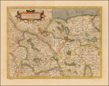
This map of Prussia, after the work of Gaspar Henneberg of Erlichensi, is a remarkable depiction of that region from 1630, printed in Amsterdam by Willem Janszoon Blaeu. It presents a detailed and visually captivating representation of Prussia, encompassing northeastern Poland, Lithuania, and today's Russian enclave of Kaliningrad Oblast. The map is distinguished by its elaborate cartouche, compass rose, sailing ship, and a sea monster, adding a rich aesthetic quality to its geographical precision.
The map's detailed legend, "Caracterum Hvivs Tabule Explicatio," provides insights into the various symbols used to denote cities, fortifications, monasteries, forests, and other geographical features, reflecting the period's conventions in cartographic representation.
The map depicts key locations such as Gdansk, a vital port city, and the area of Kaliningrad Oblast, a region that has seen numerous geopolitical changes over centuries.
Willem Janszoon Blaeu (1571-1638) was a prominent Dutch geographer and publisher. Born the son of a herring merchant, Blaeu chose not fish but mathematics and astronomy for his focus. He studied with the famous Danish astronomer Tycho Brahe, with whom he honed his instrument and globe making skills. Blaeu set up shop in Amsterdam, where he sold instruments and globes, published maps, and edited the works of intellectuals like Descartes and Hugo Grotius. In 1635, he released his atlas, Theatrum Orbis Terrarum, sive, Atlas novus.
Willem died in 1638. He had two sons, Cornelis (1610-1648) and Joan (1596-1673). Joan trained as a lawyer, but joined his father’s business rather than practice. After his father’s death, the brothers took over their father’s shop and Joan took on his work as hydrographer to the Dutch East India Company. Later in life, Joan would modify and greatly expand his father’s Atlas novus, eventually releasing his masterpiece, the Atlas maior, between 1662 and 1672.
![[ Poland / Lithuania / Kaliningrad ] Das Konigreich Preussenmit den freien Stadten Danzig u Thorn](https://storage.googleapis.com/raremaps/img/small/102639.jpg)
![(Second World War - Holocaust) Hitlerowskie wiezienia i areszty na ziemiach Polskich w latach 1939-1945 | Hitlerowskie obozy pracy na ziemiach Polskich w latach 1939-1945 [Nazi prisons and arrests in Poland in 1939-1945 | Nazi labor camps in Poland in 1939-1945]](https://storage.googleapis.com/raremaps/img/small/82908.jpg)
![[ Baltic, Poland, Ukraine, Russia ] Tabula VIII Europe (title on verso)](https://storage.googleapis.com/raremaps/img/small/50926.jpg)