|
||

|

|
|

|
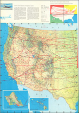
Die Steinkohlenfelder der Vereinigten Staaten von N.A., by Augustus Petermann after a map by Hitchcock & Blake and published by Justus Perthes in Gotha in 1875, offers a detailed portrayal of the coal fields in the United States of North America. Focused regions of importance are denoted with a pink hue, signifying their prominent role in coal extraction and distribution.
The late 19th century marked a pivotal period in the industrial development of the United States, with coal mining playing a crucial role in both economic growth and technological advancement. The discovery and utilization of vast coal deposits powered the nation's factories, locomotives, and ships, underscoring the United States' burgeoning status as an industrial powerhouse.
The map, with its intricate delineation, enumerates several significant coal regions, emphasizing their respective areas in English square miles. Notably, the New England and East Pennsylvania regions, both rich in anthracite coal, span 750 and 494 square miles, respectively. In stark contrast, the vast Alleghany or Appalachian coal field, abundant in bituminous coal, stretches over an impressive 59,440 square miles. The map also sheds light on other key regions such as the Michigan coal field, the Central or Illinois coal region, and the expansive Missouri or Great Western coal region, the latter covering a staggering 108,000 square miles.
Interestingly, the map draws a comparison to the area of the German Empire, calculated to be 210,444 English square miles. This juxtaposition, likely intended for a German-speaking audience, contextualizes the immense size and significance of the American coal regions, further underscoring the pivotal role of coal in shaping the nation's industrial trajectory. The map, therefore, stands as both a cartographic marvel and a historical document, capturing a pivotal moment in the industrial narrative of the United States.
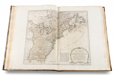
August Heinrich Petermann (1822-1878) is a renowned German cartographer of the nineteenth century. Petermann studied cartography at the Geographical Art-School in Potsdam before traveling to Edinburgh to work with Dr. A. Keith Johnston on an English edition of Berghaus’ Physical Atlas. Two years later he moved to London, where he made maps and advised exploratory expeditions as they set off to explore the interior of Africa and the Arctic.
In 1854, Petermann returned to Germany to be Director of the Geographical Institute of Justus Perthes in Gotha. There, he was the editor of the Geographische Mittheilungen and Stieler’s Handatlas. The Royal Geographical Society of London awarded him their Gold Medal in 1860. He continued his interest in exploration in Germany, fundraising for the German Exploring Expeditions of 1868 and 1869-70, which sought an open Arctic sea. Tragically, he committed suicide in 1878.
![[ US-Mexico Border Survey: General Order From the President of the United States Directing William H. Emory to lead the US-Mexico Boundary Survey ]](https://storage.googleapis.com/raremaps/img/small/101837.jpg)