|
||

|

|
|

|
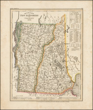
Mendenhall's Guide and Road Map of New Hampshire, published by C.S. Mendenhall in Cincinnati in 1912, offers a detailed representation of New Hampshire's transportation network at the dawn of the automobile age. With emphasis on main touring routes, good roads, connecting roads, and railroads, the map showcases the intricate network of pathways that began to shape the state's infrastructure and tourism.
The early 20th century was a transformative era for the United States, marked by the advent and popularization of the automobile. In a time preceding the widespread development of the federal highway system, state-focused road maps like Mendenhall's were invaluable to the early motorist. New Hampshire, with its rugged terrain, scenic beauty, and historical landmarks, was becoming an attractive destination for both tourists and business travelers.
The distinction made between main routes, good roads, and connecting roads highlights the varying degrees of development and accessibility of the state's transportation corridors. These categorizations offer insight into the priorities of infrastructure development and the economic, as well as recreational, significance of particular routes.
In addition to the roads, the map's inclusion of railroads underscores the still-potent relevance of rail travel during this period. While the automobile was quickly emerging as a symbol of freedom and individual mobility, railroads continued to play an essential role in the movement of people and goods, and their representation here serves as a reminder of their enduring significance.
The detailed insets of cities like Concord, Mt. Washington, Manchester, Portsmouth, Keene, and Nashua provide a more intimate view of the state's urban centers. These insets reflect the importance of these locales as hubs of commerce, culture, and transportation, and they give a nuanced portrait of New Hampshire at a pivotal moment in its evolution.
![(California Gold Rush Artist) [Autograph Letter, from American artist William McIlvaine Jr. to artist William Thompson Russell Smith, mentioning Fronconia Notch. White Mountains]](https://storage.googleapis.com/raremaps/img/small/97179.jpg)