|
||

|

|
|

|
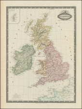
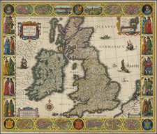
British Isles, published by William Lizars in Edinburgh circa 1828, stands as a remarkable cartographic depiction of the region. Detailed in its delineation, the map portrays the various towns, roads, and mountain ranges of the British Isles, with distinct coloration demarcating the different countries.
The late 1820s marked a period of significant political and social change in the British Isles. The momentum of the Industrial Revolution was at its peak, and the push for parliamentary reform was gaining traction, eventually culminating in the Reform Act of 1832. This map, published in the heart of such pivotal times, serves as a geographical testament to the British Isles in an era of transition. It captures not just the physical terrain, but also echoes the infrastructural advancements and political boundaries of the period.
William Lizars' engraving offers viewers a glance into the precision and expertise of 19th-century Scottish cartography. The depiction of towns and roads encapsulates the intricacies of the region's connectivity, shedding light on trade routes and communication networks of the time. The color differentiation by countries adds a layer of geopolitical understanding, presenting a clearer picture of the territorial divisions and administrative boundaries within the British Isles.
The emphasis on natural landmarks, such as mountains, further enhances the map's utility as both a geographical and topographical reference. In juxtaposition to the man-made roads and towns, these natural features stand as timeless markers, shaping the histories and narratives of the lands they inhabit, making British Isles not just a map, but a comprehensive visual narrative of a region in flux.
The Lizars were a Scottish family of engravers and printers who produced many views and maps. Daniel Lizars Sr. (1754-1812) was the son of a shoemaker, but he apprenticed with Andrew Bell, a printer and engraver. Lizars set up his own printworks near St. Giles Cathedral and took on his own apprentices, including George Bartholomew, whose son John would go on to found the important mapmaking firm later know as John Bartholomew & Son Ltd.
Daniel Sr. had three sons: Daniel Jr., John, and William Home. He also had a daughter, Jane Home. Daniel Jr. (1793-1875), the youngest of the boys, apprenticed in his father’s shop alongside George Bartholomew. When his father died in 1812, Daniel Jr. took over much of the business, expanding it and specializing in maps. The company went bankrupt in 1832, however, and Daniel emigrated to Canada.
John Lizars (1792-1860), the middle son, studied medicine and became Professor of Surgery at the Royal College of Surgeons of Edinburgh, as well as senior surgeon at the Royal Infirmary of Edinburgh.
William Home Lizars (1788-1859), the eldest, also apprenticed in his father’s shop. After learning engraving, William entered the Trustees’ Academy to learn under John Graham. He was a skilled painter and artist. When his father died, and after his Daniel Jr. left, he carried on printing and invented a method of etching that looks like wood engraving.