|
||

|

|
|

|
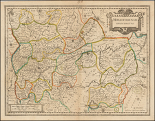
Lower Saxony, published by William Lizars in Edinburgh circa 1828, provides an intricate cartographic illustration of Lower Saxony, delineating towns, roads, forests, and other geographical features. Notably, the map includes Berlin, a city that, while outside the depicted region, is positioned prominently on its right side. Alongside this, the map encompasses areas such as the Duchy of Holstein, Duchy of Mecklenburg, and the Principality of Luneburgzell, among others.
The 1820s was a crucial period in the political and territorial reconfiguration of Europe. Following the upheavals of the Napoleonic Wars and the subsequent Congress of Vienna in 1815, the landscape of German territories was substantially reshaped. This map, therefore, provides insight into the post-Napoleonic German states, capturing the rearranged Duchies, Principalities, and Bishoprics that would eventually play roles in the formation of the German Confederation and, later, the German Empire.
William Lizars' depiction of Lower Saxony is emblematic of the intricate and detailed cartographic techniques of the early 19th century. The presence of Berlin, despite its geographical departure from Lower Saxony, could be indicative of the city's increasing prominence as a central node in Germanic territories. This inclusion offers a glimpse into the sociopolitical significance of the time, underscoring the city's burgeoning importance in the broader European context.
The careful demarcation of regions such as the Duchy of Holstein, Duchy of Mecklenburg, and the Principality of Halberstadt offers scholars and historians a valuable resource for understanding the evolving nature of territorial boundaries during this period. As such, this map stands not merely as a geographical tool but also as an artifact bearing witness to the flux and transformation of 19th-century Europe.
The Lizars were a Scottish family of engravers and printers who produced many views and maps. Daniel Lizars Sr. (1754-1812) was the son of a shoemaker, but he apprenticed with Andrew Bell, a printer and engraver. Lizars set up his own printworks near St. Giles Cathedral and took on his own apprentices, including George Bartholomew, whose son John would go on to found the important mapmaking firm later know as John Bartholomew & Son Ltd.
Daniel Sr. had three sons: Daniel Jr., John, and William Home. He also had a daughter, Jane Home. Daniel Jr. (1793-1875), the youngest of the boys, apprenticed in his father’s shop alongside George Bartholomew. When his father died in 1812, Daniel Jr. took over much of the business, expanding it and specializing in maps. The company went bankrupt in 1832, however, and Daniel emigrated to Canada.
John Lizars (1792-1860), the middle son, studied medicine and became Professor of Surgery at the Royal College of Surgeons of Edinburgh, as well as senior surgeon at the Royal Infirmary of Edinburgh.
William Home Lizars (1788-1859), the eldest, also apprenticed in his father’s shop. After learning engraving, William entered the Trustees’ Academy to learn under John Graham. He was a skilled painter and artist. When his father died, and after his Daniel Jr. left, he carried on printing and invented a method of etching that looks like wood engraving.
![[Holstein &c.] Tabula Generalis Holsatiae in qua sunt Ducatus Holsatiae, Dithemarsiae, Stormariae, Wagriae, Comitatus Pinnenbergensis et Episcopatus Lubecensis](https://storage.googleapis.com/raremaps/img/small/91164.jpg)