|
||

|

|
|

|
Stock# 78734
Description
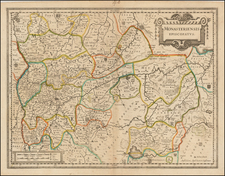
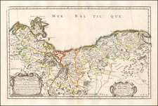
Fine and attractive map of northwestern Germany, published by Peter van der Keere in Amsterdam in the early 17th century. The map shows the region around Munster, extending from the edge of the Rhine near Essen to the North Sea at the mouth of the Weser River.
Numerous cities, towns, and more are named on the map. Forests, rivers, and bogs are indicated. The map is orientated north at the left of the map. In the lower-left, a "Waste Land" is named.
![[Denmark and Southern Sweden] Danorum Marca, vel Cimbricum, aut Daniae Regnum . . . M. D. LXXXV.](https://storage.googleapis.com/raremaps/img/small/91201.jpg)