|
||

|

|
|

|
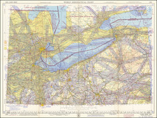
At the beginning of the 20th century, Cleveland, Ohio stood as a testimony to the rapid industrialization and urban expansion that defined the growth of many American cities. This 1912 Rand McNally map reveals the sprawling expanse of the city, highlighting its burgeoning neighborhoods, streets, and distinctive features. It captures a fascinating moment in Cleveland's history, during which the city underwent significant transformation in terms of its physical boundaries and internal organization.
The turn of the century marked a period of rapid growth for Cleveland. Industrialization brought with it a plethora of opportunities, attracting a surge of migrants looking for employment and a better life. The city's proximity to the Great Lakes made it a favorable location for industries, especially those centered on steel production, oil refining, and manufacturing. As more factories were established, they necessitated the accommodation of increasing numbers of workers. Consequently, the city saw expansive urban development both to the east and the west.
To the east, the development of areas like Cleveland Heights and Shaker Heights marked a move towards the creation of suburban residential regions. These neighborhoods, with their orderly streets and homes, became desirable locations for the middle and upper classes, offering an escape from the dense and bustling environment of the city center. Shaker Heights, in particular, was noted for its meticulously planned residential areas, served by a dedicated streetcar line that ensured residents' easy access to the heart of the city.
The map delineates the city’s neighborhoods with fabulous detail, capturing the essence of the city's dynamism. One of the fascinating features is the map’s portrayal of greenspaces, parks, and cemeteries. These spaces, often overlooked in urban histories, were central to the life of the city. They provided residents with recreational spaces, reflecting the City Beautiful movement's ideals that championed the integration of green areas into urban designs for their aesthetic and moral upliftment qualities.
Furthermore, the map prominently features the city’s railroads, highlighting Cleveland's role as a vital transportation and trade hub. These railroads connected the city to other major urban centers, facilitated the movement of goods, and played a significant role in the city's industrial growth.
Cleveland's coastline also saw a significant enhancement with the extension of the Government Breakwater. This development was paramount for the protection of the city's shoreline and for accommodating increased maritime trade activities, enabling larger vessels to anchor and fortifying Cleveland's position in the Great Lakes' trade network.
Parallel to this was the expansion of Union Depot. To accommodate the city's booming population and growing status as a transportation hub, Union Depot underwent extensive renovations. Key among these was the introduction of a new waterfront pier.
Rand McNally & Co. is a large American map and navigation company best known for its annual atlases. The company got its start in 1856, when William Rand opened a print shop in Chicago. He was joined in 1858 by a new employee, Andrew McNally. Together, the men established their namesake company in 1868. Originally, the company was intended to print the tickets and timetables for the trains running to and through Chicago; their first railway guide was published in 1869.
By 1870, they had shifted from just printing to publishing directories, travel guides, and newspapers. Their first map appeared in 1872 in a railway guide. The map was produced using a new wax engraving method, a cheaper process that gave the company an edge.
By 1880 Rand McNally had entered the education market with globes, wall maps, and geography texts for students. In 1923, Rand McNally published the first Goode’s World Atlas, named after its editor, Dr. J. Paul Goode. For generations afterward, this would be the standard classroom atlas.
In 1899, William Rand left the company, but McNally and his family remained, controlling the company for over a century. In 1904, they published their first road map intended for automobiles and by 1907 were publishing Photo-Auto Guides, which combined photography and mapping to help drivers. In 1924, they produced the Auto Chum, a precursor to their famous road atlases. Rand McNally would remain the leader in road maps and atlases throughout the twentieth century.
In 1937, Rand McNally opened its first store in New York City. Ever on the frontier of technology, Rand McNally pioneered the scribing process for printing tickets in 1958 and printed their first full-color road atlas in 1960. Arthur Robinson developed his now-famous projection of Rand McNally in 1969. By the 1980s, the company was exploring digital reproduction and digital databases of maps for truckers. In the 1990s, they lead the charge to develop trip-planning software and websites. Today, most of its products are available online or in a digital format, including maps for tablets and phones.