|
||

|

|
|

|
A Historical Dive into the San Diego River Estuary and Land Partitions of the 1890s
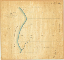
The city of San Diego has always been inextricably linked to its surrounding natural landscape. The San Diego River, a lifeline in the arid climes of the City of San Diego and environs, has been at the heart of this connection. The present referee's partition map, drawn on drafting linen, sheds light on the evolution of land partitions in the area of today's San Diego Rivger Estuary, in the late 19th century.
The Map’s Features
This schematic representation centers on the San Diego River, particularly emphasizing the levee (in red) that played a pivotal role in the redirection of the river’s flow. Where the river once meandered through Old Town, taking a southerly turn into Mission Bay, the levee now ensures a direct westward flow into the Pacific Ocean.
Adjacent to the river and southeast Mission Bay at the bottom of Mission Valley, parcels of land are demarcated. Noteworthy landowners like A. Levi, M. Olmstead, and the Carr Heirs have their plots clearly identified. Interestingly, two lots bear the label "Doe et al", indicating unknown ownership, a not uncommon occurrence in tumultuous land ownership times.
The land in question is now a part of the San Diego River Estuary and adjacent lands immediately west of where the river flows out of Mission Valley towards Mission Bay.
History of the San Diego River’s Redirection to the Pacific Ocean
The San Diego River's course has consistently shifted, subject to both nature's whims and human interventions. Before 1821, the river predominantly flowed into San Diego Harbor. However, a significant flood in 1821 altered the river's trajectory overnight, even without any coastal rainfall. This event rerouted the majority of the river into what was then known as False Bay (now Mission Bay), leaving a minor tributary still flowing into the harbor. By the mid-19th century, particularly in 1849 and 1856, the river reverted to its old path into San Diego Harbor, a change confirmed by the U.S. Coast and Geodetic Survey in 1859.
Concerns about the river depositing sediment and threatening San Diego Bay's viability prompted federal intervention in 1853. The government redirected the river to flow into Mission Bay and constructed a levee embankment from near Old Town to Point Loma. However, this change was short-lived. Heavy rainfall that same year caused the river to revert to its earlier course into the harbor.
The most significant flood in the river's history occurred in 1862, part of the larger Great Flood that affected the entire Western U.S. This flood inundated Mission Valley and, combined with winds from a southern sea storm, led to significant flooding in lower Old Town.
In 1876, after various course shifts, the levee was rebuilt. From this point onward, the river no longer diverted into San Diego Bay. Fast forward to 1935, the construction of the El Capitan Dam, located 27 miles up the river, significantly reduced sediment deposition into the bay. It's worth noting that an earlier dam had failed in 1916, leading to heightened floodwaters in Mission Valley.
San Diego Pueblo Lands: From Mexican Era to 1900
The history of land ownership in San Diego is a complex tapestry of colonial legacies, native rights, and pioneering aspirations. Before the American era, the San Diego Pueblo lands were part of a Mexican land grant system. These lands were initially owned by the Spanish crown and were later passed to Mexico after its independence. Under the Mexican secularization act of the 1830s, many of the lands once controlled by the Spanish missions were granted to private individuals.
Post the Mexican-American War and with the Treaty of Guadalupe Hidalgo in 1848, California became a U.S. territory. The transition raised numerous disputes regarding land ownership. Original Mexican land grants were supposed to be honored, but in many cases, the documentation was either lost or disputed. This resulted in a series of land partition actions in the courts. The process of settling these claims was often complex and protracted. All the while, existing landowers would sell, subdivide or otherwise transfer their landholdings or pass them down to heirs. In some cases, these included largely abandoned possessory or ownership claims or heirs not living in the area.
The partition action of 1890, as depicted on the schematic map, is one such chapter in this long narrative. Such partitions were often contentious, revealing a mosaic of claims from different eras and diverse stakeholders.
In summary, the schematic map on drafting linen is not just a representation of geographical features and land partitions; it's a historical document. It encapsulates the transformative changes in the San Diego region during the 19th century – from the redirection of a major river to the legal and social challenges of land ownership in a rapidly evolving frontier.
![[ Wetmore & Sanborn's Addition / Mount Hope Cemetery Central Park Addition ] Plat of Cemetery Road (Imperial Avenue)](https://storage.googleapis.com/raremaps/img/small/96533.jpg)