


|
||

|

|
|

|
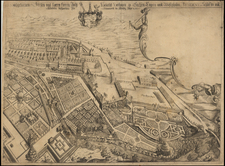
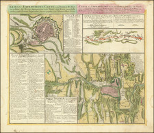
Interesting pair of battle maps, showing the Siege of Prague in 1742.
This map provides a detailed depiction of the military expeditions in Bohemia during the War of the Austrian Succession. It focuses specifically on the siege of Prague, detailing the strategic positions and maneuvers of both the attacking and defending forces from July 28 to October 13, 1742.
The central feature of the map is the city of Prague and its fortifications, depicted with precision to illustrate the military defenses and the surrounding terrain. The map shows the various lines of attack by the Austrian forces and the defensive positions held by the French. Key locations within and around Prague are marked, showing fortifications, trenches, and troop placements.
The map includes a comprehensive legend and annotations detailing the sequence of events during the siege. The left side of the map provides a legend explaining symbols used for different fortifications and military works, such as batteries, trenches, and redoubts. The central section, titled "De l'Attaque," describes the actions and movements of the attacking forces, including the establishment of batteries and the progression of their siege works. The right section, "De la Defense," outlines the defensive measures taken by the French, including counterattacks and reinforcements. Additional annotations in German, from a later edition of the map, offer a day-by-day register of the siege events, providing further details on the significant actions and outcomes during the siege.
The siege of Prague was a significant event during the War of the Austrian Succession, involving complex military maneuvers and engagements. This map, created by the heirs of the famous cartographer Johann Baptist Homann, captures the strategic intricacies of the siege. It reflects the cartographic precision and military knowledge of the period, providing a valuable historical document for understanding the siege's dynamics. A note on the map emphasizes the importance of accuracy and reliability in its creation, acknowledging the use of information from various French engineers to ensure a comprehensive representation of the events.
Siege of Prague
The Siege of Prague was an extended blockade of Prague by the Austrian Army, during the War of the Austrian Succession. Under the command of de Broglie, the French forces in control of Prague were surrounded by a large Austrian army in June 1742. A French relief column forced the Austrians to partially lift the siege in September, which allowed de Broglie to escape, leaving the French occupying force under the command of Belle-Isle.
When the Austrians renewed the siege, conditions in the city became quite difficult, but the Austrians failed to maintain a tight cordon around the city. On December 16, 1742, Belle-Isle led 14,000 troops out of the city on a ten-day march to the French-held city of Cheb. Belle-Isle's forces reached the Bohemian Forest 4 days later.
When the Austrian command learned of the French departure on December 18, 1742, they mistakenly believed their force controlled the escape routes escape, but Belle-Isle was able to lead his army off the road and into the mountains and on to Cheb, reaching the city of December 26, 1742.
Homann Heirs was a German publishing firm that enjoyed a major place in the European map market throughout the eighteenth century. Founded in 1702 by Johann Baptist Homann, the business passed to his son, Christoph, upon Johann’s death in 1724. Christoph died in 1730, aged only 27, and the firm was inherited by subsequent Homann heirs. This altered the name of the company, which was known as Homann Erben, or Homann heirs. The firm continued in business until 1848.
![[Nové Zámky / Érsekújvár, Slovakia] La famosissima Piazza di Neuhausel nelli Confini di Ungaria assediata da Turchi li 13 Agosto 1663](https://storage.googleapis.com/raremaps/img/small/75781.jpg)
![[ Holy Roman Empire ] A Newe Mape of Germany Newly Augmented by Iohn Speed Ano Dom: 1626](https://storage.googleapis.com/raremaps/img/small/68482.jpg)

![(Czech Settlement in Manitoba) Mapa státu: Manitoba a kanádského Severozápadu s rozlíčnym železničním spojením a českymi a německymi osady | Manitobe Nove Cechy Hohenlohe-Langeburg [State Map: Manitoba and the Canadian Northwest with railway connections, including Czech and German settlements | Manitoba, New Cezchia]](https://storage.googleapis.com/raremaps/img/small/88274.jpg)