


|
||

|

|
|

|
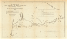
Mapping The Four Corners
This German map, crafted meticulously, encapsulates a period of intense geographical exploration in the Southwest region of the United States from 1869 to 1876. It is a reductive representation of the topographical surveys conducted by prominent American geologists and explorers, George Wheeler and Ferdinand Vandeveer Hayden. The map, skillfully compiled by the renowned geographer August Heinrich Petermann, provides a snapshot of an era characterized by the pursuit of geographical knowledge and expansion of the frontier.
The Wheeler Survey, officially known as the Geographical Surveys West of the 100th Meridian, and the Hayden Survey, known as the Geological and Geographical Survey of the Territories, were significant scientific explorations aimed at mapping the largely uncharted territories of the Southwestern United States. They covered a vast array of geographical features, encompassing everything from the Colorado River basins to the high plateaus of Utah.
George Wheeler's surveys offered comprehensive geodetic data, using triangulation methods to provide detailed geographical and topographical information. In contrast, Ferdinand Hayden's surveys focused on the geological features, flora, fauna, and native cultures in the regions of Colorado, Utah, Nebraska, and Wyoming.
Petermann's edition of these surveys intricately presents the geographical complexities, geological marvels, and human settlements of the American Southwest. The map's detail showcases the topographical variety of the region, from imposing mountains and expansive deserts to snaking rivers and hidden valleys. The blend of Wheeler's precise triangulation with Hayden's rich geological and anthropological data creates a holistic visual document of these territories, a testament to the spirit of exploration and discovery during the period.
August Heinrich Petermann, the compiler of this map, was a noted German cartographer known for his pivotal role in the development of modern cartography. Throughout his career, he published a wide variety of geographical publications, including the esteemed Petermanns Geographische Mitteilungen. This journal was widely regarded for its detailed maps and exploratory reports, covering new discoveries and research from various parts of the world. Petermann’s contribution to the field of cartography, as evident in the meticulously compiled maps like the one described, greatly enhanced our understanding of the Earth's geography.
Rarity
The map is scarce. This is the first example we have offered for sale.
August Heinrich Petermann (1822-1878) is a renowned German cartographer of the nineteenth century. Petermann studied cartography at the Geographical Art-School in Potsdam before traveling to Edinburgh to work with Dr. A. Keith Johnston on an English edition of Berghaus’ Physical Atlas. Two years later he moved to London, where he made maps and advised exploratory expeditions as they set off to explore the interior of Africa and the Arctic.
In 1854, Petermann returned to Germany to be Director of the Geographical Institute of Justus Perthes in Gotha. There, he was the editor of the Geographische Mittheilungen and Stieler’s Handatlas. The Royal Geographical Society of London awarded him their Gold Medal in 1860. He continued his interest in exploration in Germany, fundraising for the German Exploring Expeditions of 1868 and 1869-70, which sought an open Arctic sea. Tragically, he committed suicide in 1878.

![[ Colorado ]](https://storage.googleapis.com/raremaps/img/small/99487.jpg)
![Parts of E. California and S. E. Nevada, N.W. Arizona and S.W. Utah __ Atlas Sheet No. 66 [Shows Las Vegas!]](https://storage.googleapis.com/raremaps/img/small/92030.jpg)