|
||

|

|
|

|
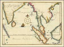
The Finest Example of this Map of Which We Are Aware. A Superlative of Incunable Hand Coloring.
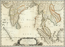
A truly exceptional example of the second map ever produced of the region now known as Pakistan, from the all-important 15th-century Rome Ptolemy atlas.
While the map is highly desirable in its own right, even without coloring, this example possesses fantastic early hand coloring. Colored examples of maps from the Rome Ptolemy are of the utmost rarity to begin with, but even when present, this coloring tends to be primitive and of limited detail. The coloring on this example represents one of the most finely colored 15th-century printed maps we have ever seen. The shading of mountains, coloring of rivers, and graticulated border are the work of a superb colorist making a premium example of the map for an important recipient.
Not only is the coloring of this map excellent, but there is evidence that it was gold heightened and painted with lead white. Robert Peerlings, the leading expert on the Rome Ptolemy atlas, has identified a few examples of maps from the same atlas. Having subjected these maps to x-ray spectroscopy, he concluded that the maps were heightened in gold and had lead white paint applied. He states about the maps that:
"We now know that these maps belong to the second edition of the Rome Cosmography published in 1490 by Petrus de Turre. During our research we found very few coloured examples in all studied atlases. If they were coloured at all, it was fairly basic . . . Thus, it can be concluded that these map belong to the 1490 edition of the Rome Cosmography, that they were old or contemporary coloured and that they were gold heightened. This makes these maps very special or rather unique."
Peerlings further demonstrates that the maps were either contemporarily colored (e.g., in 1490) or colored in the first half of the 16th century. His full analysis can be read here.
The Rome Ptolemy was first published in 1478, immediately after the rudimentary Bologna Ptolemy in 1477, the first atlas ever published. The Rome edition was produced by the German master engraver Conrad Swenheym who had established the first printing press in Italy and had devoted the final years of his life to producing this work. It was published posthumously by Swenhemy's assistant Arnold Buckinck, first in 1478 and then reissued in 1490, 1507, and 1508. The different editions of the maps can be identified through the watermarks, with this map dating to 1490. The work was massively influential and copies made their way throughout Europe, with one example of the work known to have provenance to Christopher Columbus himself.
While produced in the 15th century, the geography shown dates to the 2nd century geographer Claudius Ptolemy. His system of co-ordinates was lost to Western scholars for some twelve centuries before being translated into Latin by Jacopo Angeli in 1406 as a key early Renaissance development. This translation was accompanied by a set of maps derived from the coordinate system, which showed parts of Europe, Africa, and Asia. This map shows the region around Pakistan, stretching from the Indus River Valley to the east to the hills of Arabia to the west.
In conclusion, this map is important not just for its representation of the region but for the marvelous coloring it displays. Hand-colored incunables are always of the utmost rarity, with a few notable exceptions, but an incunable colored with this level of care and lavishness is all but unheard of on the modern antiquarian market.
The Watermarks in the Rome Editions of Ptolemy’s Cosmography and More (Robert Peerlings)
Claudius Ptolemy (fl. AD 127-145) was an ancient geographer, astronomer, and mathematician. He is known today through translations and transcriptions of his work, but little is known about his life besides his residence in Alexandria.
Several of his works are still known today, although they have passed through several alterations and languages over the centuries. The Almagest, in thirteen books, discusses astronomy. It is in the Almagest that Ptolemy postulates his geocentric universe. His geometric ideas are contained in the Analemma, and his optical ideas were presented in five books known as the Optica.
His geographic and cartographic work was immensely influential. In the Planisphaerium, Ptolemy discusses the stereographic projection. Perhaps his best-known work is his Geographia, in eight books. However, Ptolemy’s ideas had been absent from western European intellectual history for roughly a thousand years, although Arab scholars interacted with his ideas from the ninth century onward.
In 1295, a Greek monk found a copy of Geographia in Constantinople; the emperor ordered a copy made and the Greek text began to circulate in eastern Europe. In 1393, a Byzantine diplomat brought a copy of the Geographia to Italy, where it was translated into Latin in 1406 and called the Cosmographia. The manuscript maps were first recorded in 1415. These manuscripts, of which there are over eighty extant today, are the descendants of Ptolemy’s work and a now-lost atlas consisting of a world map and 26 regional maps.
When Ptolemy’s work was re-introduced to Western scholarship, it proved radically influential for the understanding and appearance of maps. Ptolemy employs the concept of a graticule, uses latitude and longitude, and orients his maps to the north—concepts we take for granted today. The Geographia’s text is concerned with three main issues with regard to geography: the size and shape of the earth; map projection, i.e. how to represent the world’s curve proportionally on a plane surface; and the corruption of spatial data as it transfers from source to source. The text also contains instructions as to how to map the world on a globe or a plane surface, complete with the only set of geographic coordinates (8000 toponyms, 6400 with coordinates) to survive from the classical world.
![West Bengal Tourist Map [on verso:] Guide Map of Calcutta](https://storage.googleapis.com/raremaps/img/small/97639.jpg)