|
||

|

|
|

|
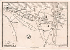
Hyderabad-Published Map of the Surrounding Region
Rare, Indian-published map of the roads surrounding Hyderabad, issued by the Chief Engineer and Secretary Mathur ad Mirza and published by the Government Central Press.
The map shows Hyderabad and its surroundings in fine detail. Many roads, railway lines, cities, towns, rivers, and much more are all shown. Also shown are bridges, unbridged streams, inspection bungalows, and petrol stations.
The map was issued by the Public Works Department of Hyderabad and evidently constitutes the best mapping of the region at the time.
Provenance
This map contains manuscript showing additional rail lines under construction in two parts of the Hyderabad region. The map was seemingly edited by someone with knowledge of the progress of the Public Works Department.
Dating
The map shows the completion of the railway to Kotahgudam, near Bhadrachalam on the Godavari River. This railway was completed in 1927. The map mentions Inspection and Travellers Bungalows, which were renamed following the Raj period. The construction of the map suggests a date from the 1920s or 1930s.