|
||

|

|
|

|
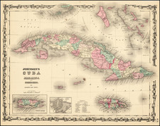
Fine large 1912 map of Cuba, reflecting not only the geographical features of the island but also capturing the burgeoning infrastructure and commercial life of the early 20th century.
The main focus of the map is the depiction of Cuba's major territories, yet what sets it apart are the inset maps detailing the ports and harbors of Havana, Matanzas, Cardenas/Santa Clara, Cienfuegos, and Santiago de Cuba, as well as the inclusion of a list of 13 railroads marked in red.
Havana, the capital and largest city of Cuba, was a critical port and commercial hub. The inset map of Havana's port and harbor from 1912 illustrates its strategic importance, with its natural harbor providing a refuge for naval fleets and commercial shipping. The harbor was a nexus for international trade, and its proximity to the U.S. made it a gateway to the Caribbean.
The port of Matanzas was known for its rich cultural heritage and sugar production. The 1912 map's portrayal of Matanzas' harbor reflects its position as an essential export center for sugar and other agricultural products. Matanzas was also a center for cultural exchange, owing to its port's connectivity with various Caribbean nations.
The inset map of the Cardenas and Santa Clara ports provides a glimpse into two essential locations in northern Cuba. Cardenas was an important fishing and trade center, and its harbor was crucial for maritime activities. Santa Clara, although more inland, was significant for its railway connections and agricultural prominence.
Cienfuegos, also known as "The Pearl of the South," was another vital port. The 1912 map shows its harbor's unique geographical features, which allowed for a deep port facility. Cienfuegos became a key hub for sugar, coffee, and tobacco trade, benefiting from its advantageous position on Cuba's southern coast.
Santiago de Cuba's port was another cornerstone of Cuban maritime activity. Its inset map shows a protected bay that facilitated both naval and commercial operations. As the second-largest city in Cuba, Santiago's port was significant for the regional economy and was historically important during the Spanish-American War.
Cuba's Railroads in the Early 20th Century
The inclusion of 13 railroads in red attests to Cuba's rapidly expanding railroad network during the early 20th century. At this time, the railroad system was crucial in connecting Cuba's primary ports with the interior, especially the agricultural zones.
The first decades of the 20th century witnessed significant investments in Cuba's rail infrastructure, driven by the booming sugar industry. Railroads facilitated the efficient transport of sugar cane to mills and ports, and the connectivity they provided helped integrate various regions of Cuba. Foreign investments, primarily American, played a vital role in the expansion and modernization of the rail system, making it one of the most extensive in Latin America.
Rand McNally & Co. is a large American map and navigation company best known for its annual atlases. The company got its start in 1856, when William Rand opened a print shop in Chicago. He was joined in 1858 by a new employee, Andrew McNally. Together, the men established their namesake company in 1868. Originally, the company was intended to print the tickets and timetables for the trains running to and through Chicago; their first railway guide was published in 1869.
By 1870, they had shifted from just printing to publishing directories, travel guides, and newspapers. Their first map appeared in 1872 in a railway guide. The map was produced using a new wax engraving method, a cheaper process that gave the company an edge.
By 1880 Rand McNally had entered the education market with globes, wall maps, and geography texts for students. In 1923, Rand McNally published the first Goode’s World Atlas, named after its editor, Dr. J. Paul Goode. For generations afterward, this would be the standard classroom atlas.
In 1899, William Rand left the company, but McNally and his family remained, controlling the company for over a century. In 1904, they published their first road map intended for automobiles and by 1907 were publishing Photo-Auto Guides, which combined photography and mapping to help drivers. In 1924, they produced the Auto Chum, a precursor to their famous road atlases. Rand McNally would remain the leader in road maps and atlases throughout the twentieth century.
In 1937, Rand McNally opened its first store in New York City. Ever on the frontier of technology, Rand McNally pioneered the scribing process for printing tickets in 1958 and printed their first full-color road atlas in 1960. Arthur Robinson developed his now-famous projection of Rand McNally in 1969. By the 1980s, the company was exploring digital reproduction and digital databases of maps for truckers. In the 1990s, they lead the charge to develop trip-planning software and websites. Today, most of its products are available online or in a digital format, including maps for tablets and phones.
![A New & Accurate Map of the Island of Cuba [on sheet with:] A New & Accurate Map of the Islands of Hispaniola and Porto Rico . . .](https://storage.googleapis.com/raremaps/img/small/77174.jpg)
![Cuba, Jamaica and Porto Rico [Cayman Islands]](https://storage.googleapis.com/raremaps/img/small/78708.jpg)