


|
||

|

|
|

|
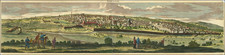
Finely colored example of this decorative view of 16th-century Jerusalem, as viewed from the east, probably from the vantage point of the Mount of Olives.
Finely crafted view of jerusalem from Braun & Hogenberg's "Civitates Orbis Terrarum," the most famous work of urban cartography from the 16th century. The perspective of the city is from the east, likely observed from the Mount of Olives, offering a comprehensive panorama of Jerusalem's architectural and geographical features.
At the top is reference to "Ezechielis V." This is a reference to the Book of Ezekiel from the Bible, specifically Chapter 5. Alongside this reference is the Latin phrase, "Hæc est Ierusalem, Ego eam in medio Gentium posui, et in eius circuitu terras," which translates to "This is Jerusalem, I have set it in the middle of the nations, and countries are all around her." This statement, a direct quotation from the Prophet Ezekiel, sets a spiritual context for the image.
The view of Jerusalem presented in this work was likely based on the drawings of the Venetian artist Domenico dalle Greche, who journeyed to the Holy Land as part of a pilgrimage in 1546, in the company of Czech nobleman Voldrich Prefat z Vlkanova.
A cartouche to the right of the image serves as a key, marking out 48 individual points of interest across the cityscape. Most of these landmarks are of Christian significance, highlighting the religious importance of the city.
However, it's important to note that during the period this view was created, Jerusalem was under Islamic rule, as represented by the five figures in the foreground. Furthermore, the skyline is punctuated by structures adorned with minarets and crescent moon symbols, typical of Islamic architecture. The most recognizable of these is the Dome of the Rock, demonstrating the city's multicultural and multireligious tapestry.
Georg Braun (1541-1622) was born and died in Cologne. His primary vocation was as Catholic cleric; he spent thirty-seven years as canon and dean at the church St. Maria ad Gradus, in Cologne. Braun was the chief editor of the Civitates orbis terrarum, the greatest book of town views ever published. His job entailed hiring artists, acquiring source material for the maps and views, and writing the text. In this role, he was assisted by Abraham Ortelius. Braun lived into his 80s, and he was the only member of the original team to witness the publication of the sixth volume in 1617.
Frans Hogenberg (ca. 1540-ca. 1590) was a Flemish and German engraver and mapmaker who also painted. He was born in Mechelen, south of Antwerp, the son of wood engraver and etcher Nicolas Hogenberg. Together with his father, brother (Remigius), uncle, and cousins, Frans was one member of a prominent artistic family in the Netherlands.
During the 1550s, Frans worked in Antwerp with the famous mapmaker Abraham Ortelius. There, he engraved the maps for Ortelius’ groundbreaking first atlas, published in Antwerp in 1570, along with Johannes van Deotecum and Ambrosius and Ferdinand Arsenius. It is suspected he engraved the title page as well. Later, Ortelius supported Hogenberg with information for a different project, the Civitates orbis terrarium (edited by Georg Braun, engraved by Hogenberg, published in six volumes, Cologne, 1572-1617). Hogenberg engraved the majority of the work’s 546 prospects and views.
It is possible that Frans spent some time in England while fleeing from religious persecution, but he was living and working in Cologne by 1580. That is the city where he died around 1590. In addition to his maps, he is known for his historical allegories and portraits. His brother, Remigius, also went on to some fame as an engraver, and he died around the same time as his brother.
![[Jerusalem] Waerachtige beschryvinge vande wydvermaerde Conincklicke Hooft Stadt Ierusalem . . .](https://storage.googleapis.com/raremaps/img/small/96558.jpg)
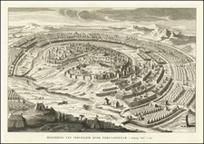
![(Czech Edition) Konterfekt Swatého Města Geruzaléma [A Depiction of the Holy City of Jerusalem]](https://storage.googleapis.com/raremaps/img/small/93469.jpg)
![[Historical Time Line Map -- Creation To 100 AD] Tableau de L'Histoire Sainte Depuis La Creation du monde jusqu'a la dispersion du Juifs . . .](https://storage.googleapis.com/raremaps/img/small/82069.jpg)