|
||

|

|
|

|
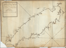
Published in London in 1729 by the esteemed geographer Herman Moll, The Island of Antego presents a detailed and fascinating map of Antigua, meticulously depicting various features such as churches, forts, windmills, plantations, cattle mills, and submerged rocks, with depths illustrated by soundings.
Herman Moll's mapping of Antigua comes during a period of European exploration, colonization, and commercial expansion in the Caribbean. As a prominent cartographer in early 18th-century London, Moll played a vital role in providing accurate geographical information for navigators, merchants, and colonial administrators. His maps, such as this one of Antigua, often included detailed annotations and symbols, offering not only geographical insight but also economic and strategic information relevant to the period's mercantile and maritime interests.
The map's remarkable features, including its unique symbols for different types of windmills and the demarcation of significant sugar plantations, reflect Antigua's socio-economic landscape. These features capture the island's centrality in the sugar trade, one of the driving forces of the British colonial economy in the Caribbean. The inclusion of churches, forts, and soundings further enhances its value for understanding the island's settlement pattern, defense structures, and navigational challenges.
The precision and artistry with which Moll approached this map embody the scientific and empirical spirit of the Enlightenment era. His focus on both natural features, like rocks underwater, and human-made structures, like cattle mills, illustrates an integrative understanding of the island's geography. This integration of diverse elements underscores the complexity of cartographic representation in a period marked by rapid geographical discovery and increased global interaction.
States
This is the third state of four, with the joint imprint of John and Thomas Bowles.
Herman Moll (c. 1654-1732) was one of the most important London mapmakers in the first half of the eighteenth century. Moll was probably born in Bremen, Germany, around 1654. He moved to London to escape the Scanian Wars. His earliest work was as an engraver for Moses Pitt on the production of the English Atlas, a failed work which landed Pitt in debtor's prison. Moll also engraved for Sir Jonas Moore, Grenville Collins, John Adair, and the Seller & Price firm. He published his first original maps in the early 1680s and had set up his own shop by the 1690s.
Moll's work quickly helped him become a member of a group which congregated at Jonathan's Coffee House at Number 20 Exchange Alley, Cornhill, where speculators met to trade stock. Moll's circle included the scientist Robert Hooke, the archaeologist William Stuckley, the authors Jonathan Swift and Daniel Defoe, and the intellectually-gifted pirates William Dampier, Woodes Rogers and William Hacke. From these contacts, Moll gained a great deal of privileged information that was included in his maps.
Over the course of his career, he published dozens of geographies, atlases, and histories, not to mention numerous sheet maps. His most famous works are Atlas Geographus, a monthly magazine that ran from 1708 to 1717, and The World Described (1715-54). He also frequently made maps for books, including those of Dampier’s publications and Swift’s Gulliver’s Travels. Moll died in 1732. It is likely that his plates passed to another contemporary, Thomas Bowles, after this death.
![[Heighted with Gold] Pascaert Vande Caribes Eylanden](https://storage.googleapis.com/raremaps/img/small/91150.jpg)
![Cuba Insula [with] Hispaniola Insula [with] Ins. Jamaica [with] Ins. S. Ioannis [with] I.S. Margareta [with] Havana portus](https://storage.googleapis.com/raremaps/img/small/95302.jpg)

![Guadaloupe [with] Antigua [with] Mariegalante &c.](https://storage.googleapis.com/raremaps/img/small/72024.jpg)