


|
||

|

|
|

|
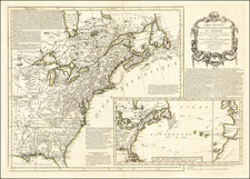
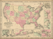
Colored By Military Departments
A nice example of the first state of Johnson's Military map of the United States.
The Johnson's New Military Map of the United States is an informative representation of the country during the time of its creation. It uniquely emphasizes the military divisions of the nation, with each division represented in a distinct color for clarity. In 1861, the year marking the start of the American Civil War, the U.S. military organization comprised of various departments, each responsible for specific geographical areas. Here is a brief outline of these departments:
-
Department of the East: Headquartered in Fort Columbus, New York Harbor, it covered the area east of the Mississippi River and east of Minnesota. Major General John E. Wool commanded it during the early Civil War period.
-
Department of the West: This department encompassed the area west of the Mississippi and east of the Rocky Mountains. Headquartered at the St. Louis Arsenal, Missouri, it initially fell under the command of Brigadier General William S. Harney.
-
Department of Texas: This was responsible for military operations in the state of Texas, which had joined the Confederacy in February 1861. Colonel Carlos A. Waite was the last Union commander of the department before it fell under Confederate control.
-
Department of New Mexico: Encompassing the territories of New Mexico and Arizona, the department played a key role in the Western theatre of the Civil War, particularly in the Apache Wars. Colonel Edward R. S. Canby was its commander in 1861.
-
Department of Utah: This department covered the Utah Territory and was pivotal in maintaining order during the period of early settlement in the West. Brigadier General P.E. Connor commanded it from Camp Douglas, aimed at protecting the overland routes from the local Native American tribes.
-
Department of California: This department included the states of California and Nevada, territories that were far removed from the main battlefronts but still played a significant role in the Civil War. Brigadier General Albert Sidney Johnston commanded it before his resignation to join the Confederate Army.
-
Department of Oregon: Including the present-day states of Oregon, Washington, and parts of Idaho, the Department of Oregon was established to facilitate military actions during the ongoing conflicts with Native American tribes. Brigadier General George Wright was its commander in 1861.
These departments served to organize and administer the Union Army's vast wartime efforts during the Civil War, providing strategic, logistical, and command oversight across the geographical expanse of the United States.
The map's standout feature is its nine insets, detailing specific southern harbors, namely Baltimore, Washington DC, Hampton Roads, Charleston, Savannah River, Key West, Pensacola, Mobile Bay, and New Orleans. These insets offer a close-up view of these vital areas, providing a detailed layout of their geographic and strategic features.
Although later editions of the map, colored by states, are more common, this particular Military Districts map is scarcer and often considered more desirable due to its unique focus on military divisions. It offers a detailed view of the country's military posts, forts, and divisions during a key period in United States history.
Alvin Jewett Johnson (1827 - 1884) was an American map publisher. Born in Wallingford, Vermont, he received only a basic public education, but he still served as a school teacher for several years before moving to Richmond, Virginia and, in 1857, New York City. Johnson also worked as a book canvasser for the map publisher J.H. Colton.
Johnson's name first appears on maps published with Samuel N. Gaston and D. Griffing Johnson (no clear relation) in the mid-1850s, and his name (along with Ross Browning) appeared on Colton's atlas maps of 1859 and 1860. Although map historian Water Ristow speculates that Colton sold his copyrights to Johnson and his business partner, fellow Vermonter Browning, a more likely theory is that Johnson and Browning financially bailed out the Colton firm in exchange for the right to use Colton’s existing copyrighted map plates. The first Johnson maps were mostly reissues of earlier Colton maps. Indeed, Johnson's earliest works described his firm as the “Successors to J. H. Colton and Company”. Johnson converted the original Colton steel plate engravings to lithographic stones, allowing his firm to produce more maps at a lower price point.
In 1860, the Johnson firm published its first significant work, the Johnson’s New Illustrated (Steel Plate) Family Atlas. The first edition of the Atlas bears imprints in both New York and Richmond, VA. In 1861, however, following the outbreak of the American Civil War, the Johnson & Browning firm abandoned their Richmond location. Browning seems to have remained in Virginia to pursue other ventures and, in 1861, Browning’s portion of the firm was purchased by Benjamin P. Ward. The 1863 issue of the Atlas was one of the most unusual, it being a compilation of older Johnson and Browning maps, updated 1862 Johnson and Ward maps, and newer 1863 maps with a revised border design.
The 1864 issue of the Atlas is the first true Johnson and Ward atlas. Johnson published one more edition in partnership with Ward in 1865, after which Johnson becomes the sole publisher. The next issue of the Atlas, 1866, is the first purely Johnson atlas with all new map plates, updated imprints, and copyrights. Johnson maps include a unique border style, which changed over the years, but was not copied by other makers. These include a “strapwork border” from 1860 to 1863, a “fretwork border” from 1863 to 1869 and a “spirograph border” in 1870.
In addition to the Family Atlas, Johnson issued numerous wall maps, pocket maps, and, in the 1880s, the Cyclopedia. Johnson frequently updated his western atlas maps and on occasion, more than one update appeared in a single year. Johnson continued to publish the Family Atlas until 1887. In 1879, Johnson brought his son into the business, and their publications have the imprint “A.J. Johnson and Son” and, later, “A.J. Johnson and Co.” Johnson’s son continued the business until it shuttered in 1887.

![[ Wyoming Attached To Dakota Territory ] The United States of America](https://storage.googleapis.com/raremaps/img/small/99363.jpg)