|
||

|

|
|

|
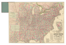
The Major American Cities, As They Stood in 1835.
Fine, original antique map of the vicinity of all the major American cities during the Andrew Jackson area, with a nice focus on the Old Northwest, the Midwest, and Appalachia.
The cities shown include:
- Portland
- Boston
- Providence
- New York
- Albany
- Baltimore
- Philadelphia
- Charleston
- Savannah
- New Orleans
- St. Louis
- Louisville
- Nashville
- Niagara Falls
- Cincinnati
The plans vary in detail, with most showing quite a large area, including nearby towns, while the Nashville map is focused solely on the city of Nashville, listing many places of interest and streets.
This map was published by Gabriel Bradford for his eponymous atlas.
Thomas Gamaliel Bradford (1802-1887) was an American geographic publisher. He hailed from Bradford, Massachusetts and began his publishing career by working for the America Encyclopedia. Then, he edited and republished the Atlas Designed to Illustrate the Abridgement of Universal Geography, Modern & Ancient, which had originally been offered in French by Adrian Balbi. In 1835, he published another atlas, A Comprehensive Atlas: Geographical, Historical & Commercial, and, in 1838, An Illustrated Atlas Geographical, Statistical and Historical of the United States and Adjacent Countries. His interests were primarily in educational publishing and he was one of the first mapmakers to show Texas as an independent country.
![[Eurpean and American Air Routes] TWA Trans World Airline U.S.A. • Europe • Africa • Asia Air Routes](https://storage.googleapis.com/raremaps/img/small/89027.jpg)
![(Puzzle Map) Mapa de America Del Norte y Central Razas y Fauna Del Continente [Map of North and Central America Races and Animals of the Continent]](https://storage.googleapis.com/raremaps/img/small/91115.jpg)