|
||

|

|
|

|
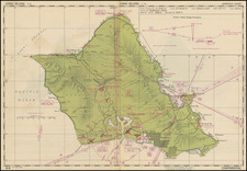
This map from the U.S. Geological Survey offers a comprehensive view of the most populous island in the Hawaiian archipelago, Oahu, as it was in 1965.
The map's scale, denoted as "1:250,000," ensures that viewers can discern both major landmarks and finer geographical nuances. Key regions such as Honolulu County and Waipahu are clearly demarcated, and the coastal expanse of Mamala Bay is distinctly outlined, emphasizing Oahu's strategic position within the Pacific Ocean.
The map's annotations and legends testify to its meticulous construction. The "RELIABILITY DIAGRAM" provides insights into the map's sourcing of data, while the "LEGEND" section deciphers the various symbols used throughout. A notable mention of the "LOCATION DIAGRAM FOR NF 4" hints at the possibility of this map being a segment of a broader collection. The blend of historical references, such as the year 1949 and photographic data from 1952, showcases the depth of research and data compilation that went into its creation.
Topographical intricacies are a standout feature of this map. The "CONTOUR INTERVAL 200 FEET" demarcation offers a glimpse into Oahu's diverse terrain, from coastal plains to elevated regions. Other essential geographical markers, including the "TRANSVERSE MERCATOR PROJECTION" and delineations like "County boundary" and "Reservation boundary," add layers of detail, making the map a valuable resource for both casual readers and professional geographers.
![[ Hawaii ] Free All Islands Map](https://storage.googleapis.com/raremaps/img/small/99157.jpg)
![[ Hawaii ] Iles Sandwich Oceanique No. 3.](https://storage.googleapis.com/raremaps/img/small/103276.jpg)
![Mort de Cook [Death of Capt. James Cook]](https://storage.googleapis.com/raremaps/img/small/96645.jpg)