|
||

|

|
|

|
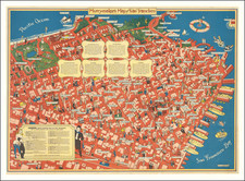
San Francisco Rebuilds
Rand McNally's large-format map of San Francisco is an impressively detailed snapshot of the city in the early 20th century. Showcasing wharfs, rail lines, street car lines, roads, buildings, and more, it offers a comprehensive perspective on the city's layout, its transportation infrastructure, and its expansion.
The map, colored with vibrant green for parks and pink for urban areas, includes a large inset of San Francisco Bay, indicating different counties. Major cities and towns such as Oakland, Sausalito, Berkeley, San Rafael, and Palo Alto are clearly marked. One of the most striking features is the detailed depiction of the city’s rebuilding efforts following the devastating 1906 earthquake.
The earthquake, and the subsequent fires, significantly damaged much of San Francisco. However, the 1912 map shows a city in the process of robust reconstruction. The rebuilding efforts are evident in the dense network of buildings spread across the map. This is especially apparent in the areas south of Market Street, where the network of streets has been completely redone.
Moreover, the 1912 map reflects the evolution of San Francisco's transit system. The city's network of streetcars and cable cars, which played a pivotal role in the city's reconstruction and expansion, is thoroughly outlined. The map displays the extensive streetcar lines crisscrossing the city, connecting new and old neighborhoods, and facilitating easy transportation of goods, services, and workers. These transit lines, essential for San Francisco's growth, highlight the city's ability to adapt and innovate in response to unprecedented challenges.
![[ Eden Township ] Residence and Farm of Lewis Knox, Residence and Farm of Lewis Knox, Eden Tp., Alameda County, California](https://storage.googleapis.com/raremaps/img/small/102040.jpg)