|
||

|

|
|

|
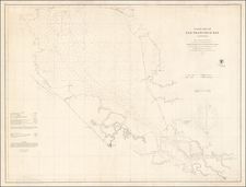
A Comprehensive Stage Coach and Railroad Map
Unusual seperately published map of the region "100 Miles Around San Fransciso", published by Punnett Brothers.
The map is a remarkable compendium of active Stage Coach routes in the region, bolding identifying the routes, distances and primary stops. Stylistically, the map stands alone in highlighting Stage Coach tranist in a way we have not seen in any other map of the region. Intended to inform shippers on relative distances, this fascinating separately published map provides an interesting snapshot of the Northern California transit distances, while also conveying basic topographical information.
While note specifically mentioned, the map also locates a number of the canals which played a major role in irrigation of the San Joaquin Valley and commerce at the end of the 19th Century.
The second title notes:
"100 Miles Around San Francisco" Or Central California
In Circles Of Five Miles Each, It Shows The Distance of Any Point From San Francisco
This Map embraces all or part of 32 Counties out of a total of 58; but coves only about 1/6 of the entire area of the State.
The only Map that shows POSTAL and STAGE ROUTES and LOCATION OF POST-OFFICES and DISTANCES BETWEEN OFFICES.
Shows 1,720 Miles of Railroads and all Stations, and distances between each station.
Population by census of 1890 of each County and chief Towns is given under the name of each.
It gives the length and terminal point of 26 railroad lines which termintae within this area and distance of terminus from San Francisco
Elevation of chief Mountains, Peaks, Lakes, Resorts, and Places of Interest and how to reach them.
The map llustrates Railroads (in red) and Stage Routes (yellow), as well as offering a key above the title that explains township plats. Radiatingout from San Francisco Bay is a schematic list of 16 steamship destinations ranging from other parts of California to Hong Kong, Yokahama, Honolulu, Alaska, Puget Sound, New Zealand and Australia.
The map was advertised for sale by thge Elliott Publishing Company of San Francisco and New York in 1891.
Rarity
The map is extremely rare. We locate only the example at the Huntington Library.
![San Francisco [June] 1849.](https://storage.googleapis.com/raremaps/img/small/97028.jpg)