|
||

|

|
|

|
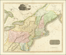
Published by Edward Stanford in London on August 21st, 1861, Stanford's Map of the Seat of War in America. Sheet I. is a beautiful hand-colored lithographed folding map of the Mid-Atlatnic States. With its subject matter focused on the early stages of the American Civil War, this map serves as a valuable primary source from a tumultuous period in United States history.
In the larger context of the war, the map provides a European perspective on the conflict, illustrating the areas of intense military engagements. The map, dissected and mounted on linen, is preserved in its original case, attesting to the quality of its construction and the care taken in its preservation.
A series of cities between Carlisle, Pennsylvania, and Richmond, Virginia, including the prominent site of Gettysburg, are underlined in red. This highlights these locations' significance as key strategic points during the war, marking the trajectories of army movements and potential battlegrounds.
Perhaps most notably, the map's creation date places it during the first year of the Civil War, providing a snapshot of the conflict's early phase. This temporal positioning allows viewers to trace the progression of the war from its initial stages, offering valuable insights into the shifting geographical and strategic landscape of this critical period in American history.
Overall, Stanford's Map of the Seat of War in America. Sheet I. provides a vivid window into the geographical realities of the American Civil War, bridging the gap between historical events and their physical settings. It remains a significant map for scholars and collectors alike, offering a detailed and nuanced picture of the United States during a time of intense internal strife.
Edward Stanford (1827-1904) was a prominent British mapmaker and publisher. A native of Holborn in the heart of London, Edward was apprenticed to a printer and stationer at the age of 14. After his first master died, he worked with several others, including Trelawny W. Saunders of Charing Cross. Saunders oversaw young Edward’s early career, ensuring that he became a Fellow of the Royal Geographical Society. Associations with the Society eventually brought Sanders much business and gave him a reputation as a publisher of explorers. As testament to this reputation, the Stanford Range in British Columbia was named for him by John Palliser.
Stanford briefly partnered with Saunders in 1852 before striking out on his own in 1853. He was an agent for the Ordnance Survey, the Admiralty, the Geological Survey, the Trigonometrical Survey of India, and the India Office. He also controlled the maps of the Society for the Diffusion of Useful Knowledge, another lucrative source of income. In 1857, Stanford founded his namesake Geographical Establishment, with Saunders and A. K. Johnston as engravers. Thereafter, Stanford was known for his “library maps”, particularly those of Africa and Asia.
Addresses and Years of Operation:
- 6 Charing Cross, London (1848): Edward Stanford's initial place of employment at Trelawney Saunders' shop.
- 7 and 8 Charing Cross, London (1853): Stanford expanded his shop to these addresses.
- 55 Charing Cross, London (1873): The shop moved to this larger location.
- 12-14 Long Acre, London (1873): Site of the new print works and current flagship store.
- 7 Mercer Walk, London (2019): Stanfords moved to this address, continuing its legacy.
Stanford's work with Chief Cartographer John Bolton, including the 1858 Library Map of Europe, positioned the company as a leader in quality cartography during a time of exploration and colonialism. Their 1862 Library Map of London earned acclaim from the Royal Geographical Society. With the business thriving, Stanford purchased Staunton & Son in 1877 and, upon retiring in 1885, handed over the reins to his son, Edward Stanford II.
As sole agents for Ordnance Survey Maps, the company's influence and reputation grew, culminating in the Stanford’s London Atlas Of Universal Geography, which was presented to Queen Victoria in 1887. The transition into the 20th century saw further integration of retail, print, and cartographic operations at Long Acre.
During World War I, Stanford's became an essential publisher for the War Office. Edward Fraser Stanford took over in 1917, steering the company through the interwar period and innovations, such as the world’s smallest maps in 1922 and the Daily Mail Motor Road Map in 1926.
Withstanding a bombing in WWII, the company continued under the stewardship of John Keith Stanford and was sold to George Philip & Son in 1947. As it adapted to the digital age, Stanfords received the Ordnance Survey Premier Partner status in 2007 and ventured into online mapping and data services.
Stanfords, now an icon for travellers and explorers, has maintained its cultural relevance and retail success well into the 21st century, underpinned by a legacy of entrepreneurial spirit and commitment to cartographic excellence.

![[Pennsylvania, New Jersey, New York ] Speciel Land Charte von Pensilvanien, Neu Jersey, Neu York und von denen drey Land-schafften an dem Delaware Fl. In America in Englischer Spr. gedruckt A. 1749 In Europa duffgelegt in Teutsch Spr. zu Francfurt am M. A. 1750.](https://storage.googleapis.com/raremaps/img/small/51958.jpg)