|
||

|

|
|

|
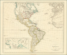
Fascinating map of North America, made under the direction of famed French naturalist Alcide Charles Victor Marie Dessalines d'Orbigny.
In the mid-19th century, North America underwent significant transformations, both geographically and politically. This map captures the essence of this transitory period, just after the Mexican War's culmination and the California Gold Rush's beginnings.
Upon close observation, the map portrays California as a state, a reflection of the rapid U.S. western expansion and the significance of the California Gold Rush in American history. The "cn dore" or gold regions are clearly marked, with a notable mention of Sutter's settlement at New Helvetia, an early Californian agricultural and trade colony established by John Sutter.
This map is particularly intriguing for its depiction of the territories. A massive Oregon Territory is evident, stretching from the Pacific to the Rockies, with the yet-to-be-named part of Minnesota Territory. The Territories of Utah and New Mexico emerge, albeit with an unresolved border dispute with Texas. This geographical indecision anticipates the Texas Compromise of 1850, where Texas relinquished its claims on parts of New Mexico in exchange for federal debt relief.
However, some of the map's most engaging aspects lie in its depiction of the then-colonial north. Alaska, labeled as Russian Territory, reflects its pre-U.S. purchase status. The vast western Canadian expanse, characterized by numerous lakes, rivers and watersheds, gives insights into the region's exploration levels. The map also highlights the significant Hudson Bay Company forts, such as Fort Norman, Ft. Enterprise, Ft. Providence, Ft. Cheaways, Ft. George, Ft. York and Ft. Churchill, indicative of the fur trade's dominance during the 19th century. The Hudson Bay Company and the Northwest Company were quintessential players in North America's fur trade, establishing numerous posts and effectively controlling fur commerce. A fort of the Northwest Company on what could be the Fraser River is shown, as are a number of "Factories" west of Lake Winnepeg.
The map, being a pre-Gadsden purchase artifact, showcases a rudimentary boundary resulting from the Treaty of Guadeloupe Hidalgo. This boundary would later be revised with the Gadsden Purchase in 1853 when the U.S. acquired parts of present-day Arizona and New Mexico, further solidifying its western dominance.
A fascinating aspect is the cartography's reliance on John Fremont's explorations, particularly in the west. The vast, uncharted "Great Desert" stands testament to the still-unexplored regions of the continent. Another captivating feature is "Mormonfort" on the Grand Lac Sal ou Timpanagos. The name "Timpanagos" has Native American origins, associated with the Timpanogos tribe, which inhabited the region around Utah Lake. This name for the lake would pre-dominate for decades.
Arizona, on this map, features a region labeled "Apacheria", marking the territories traditionally inhabited by the Apache tribe, hinting at the significant indigenous influence in the region.
Lastly, east of the Rockies, the plains echo the continent's indigenous heritage. Names of various tribes dot the landscape, coupled with mentions of early forts. Texas, an influential state in American history, features Ft. Altar, along with Austin and Nacogdoches, which would play pivotal roles in Texan history, also find their way onto this Parisian map.
The map notes that it was mde for Alcide d'Orbigny (1802-1857). Born in Couëron, France, on September 6, 1802, Alcide Charles Victor Marie Dessalines d'Orbigny hailed from a family with a profound interest in natural sciences. The d'Orbigny family's fascination with nature, particularly marine life and paleontology, deeply influenced Alcide. D'Orbigny's most notable expedition took place between 1826 and 1833 in South America, sponsored by the Paris Museum. Throughout this journey, he traveled extensively, covering over 4,000 miles on foot and 11,000 miles by horse. His excursions spanned areas from Brazil to Argentina, including the Andes.
![[ Trans-Atlantic Cable ] Amerique Septentrionale avec l'indication des Principaux Courants marins d'Amerique en Europe](https://storage.googleapis.com/raremaps/img/small/98084.jpg)
![[ Sea of the West ] L'Amerique Septentrionale divisee en ses principaux Etats . . . 1782](https://storage.googleapis.com/raremaps/img/small/80228.jpg)
![[ First Map to Name The United States ] L'Amerique septentrionale ou se remarquent les Etats Unis . . . 1779](https://storage.googleapis.com/raremaps/img/small/94192.jpg)