


|
||

|

|
|

|
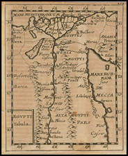
The map provides an insightful cartographic representation the area centered on Red Sea and the Lower Nile during the early 18th century. Issued in 1726 and embedded within a Jesuit relation, the map embodies a complex confluence of ecclesiastical endeavors, Imperial objectives, and scholarly pursuits.
The focus on the Red Sea and the Lower Nile situates the map at a critical nexus of ancient trade routes and empires, each with its storied history that reaches back to antiquity. The region was not just a geographical entity but a locus of myriad encounters between diverse civilizations including the Egyptians, Nubians, Romans, and later, Islamic Caliphates.
The title of the map itself reveals layers of historical interest. The term "Insula S. Claudii" invokes Saint Claudius, a figure that may refer to multiple saints, whose lives and hagiographies resonate with ecclesiastical missions in foreign lands. "Arx Imperatoris Aethiopiae," or "Fortress of the Emperor of Ethiopia," attests to the map's focus on strategic sites of power within the region. The specific reference to Ethiopia likely corresponds with the Solomonic dynasty's claims of descent from the union of King Solomon and the Queen of Sheba, a narrative deeply interwoven with Christian mythologies and thus of intense interest to Jesuit missionaries.
The map's provenance as a part of a Jesuit relation situates it within the broader corpus of Jesuit cartographic contributions. The Society of Jesus was an active participant in the scientific explorations of the era, and their maps often bore an imprimatur of scholarly rigor and meticulous detail. The Jesuit relations themselves were detailed annual reports sent back to Rome, documenting both the ecclesiastical and the ethnographic, thus providing vital contextual information that would have accompanied the map.
![(Complete Battle of the Nile Series) Battle of the Nile, the Attack and Sunset... Plate [1] [with:] Battle of the Nile, at 10 O'Clock at Night... Plate 2d. [with:] Battle of the Nile, Near Midnight... Plate 3. [and:] Battle of the Nile, on the Ensuing Morning.](https://storage.googleapis.com/raremaps/img/small/98054.jpg)
![[English Language Edition!] Natoliae Quae Olim Asia Minor Nova Descriptio [with] Aegypti Recentior Descriptio [with] Carthageinis Celeberrimi Sinus Typus [shows Cyprus]](https://storage.googleapis.com/raremaps/img/small/78508.jpg)