|
||

|

|
|

|
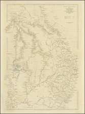
The first English map of Australia, which is derived directly from Thevenot's seminal map of 1663, showing the Dutch discoveries in the region.
Bowen's map is the first English map of New Holland. The map appeared in the revised edition of John Harris' Complete Collection of Voyages. Bowen's map adds the Tropic of Capricorn and two texts: the upper block emphasizes that no assumptions have been made, so white space abounds between New Guinea and Carpentaria, and between the mainland, Tasmania and New Zealand; the lower text starts: It is impossible to conceive a Country that promises fairer from its situation, than this of Terra Australia; no longer incognita, as this map demonstrates…
The map is derived directly from Thevenot's seminal map of 1663, showing the Dutch discoveries in the region done by the VOC. The Continent of Australia, as mentioned in the title, was surveyed by Capt. Abel Tasman.
Abel Janszoon Tasman was a Dutch seafarer, explorer, and merchant, best known for his voyages of 1642 and 1644 in the service of the Dutch East India Company (VOC). He was the first known European explorer to reach the islands of Tasmania and New Zealand and to sight the Fiji islands. During his second voyage to the pacific, he missed the Torres Strait between New Guinea and Australia, continuing his voyage westwards along the north Australian coast. He mapped the north coast of Australia making observations on the land (called New Holland). From the point of view of the Dutch East India Company, Tasman's explorations were a disappointment: he had neither found a promising area for trade nor a useful new shipping route. Although received modestly, the company was upset that Tasman didn't fully explore the lands he found and decided that a more "persistent explorer" should be chosen for any future expeditions.
The text includes reference to 'the best climate in the world', 'according to Coll. Purry'. Purry was a former employee of the Dutch East India Company interested in attracting the Dutch, French, and English to settle in Nuyts' land, to no avail. Only once Capitan Cook confirmed the assertions made by Purry did interest arise about the land.
The northern part of Australia is detailed with specific coastal features and names, indicative of the areas explored by Tasman and other European navigators of the time. The western and southern coasts are outlined, though the interior remains mostly blank, reflecting the lack of inland exploration. New Zealand, labeled here as "Zeelandia Nova," appears to the right, with its western coast roughly charted, an early depiction before a full mapping by later explorers like James Cook.
Abel Tasman's Voyages
Abel Tasman's voyages in the 17th century marked significant contributions to the European understanding and mapping of the Australasian region. Through his discoveries, Tasman charted substantial portions of the Australian continent and New Zealand, fundamentally altering European perceptions of the Southern Hemisphere.
Research delves into the historical cartography associated with Tasman's explorations, revealing how the Dutch East India Company (VOC) Tasman Map became an iconic symbol of Australian history. This map not only reflected the extent of Dutch exploration but also highlighted the competitive maritime interests and myth-making processes of the era. Tasman's voyages contributed to the geopolitical narratives of the time and were instrumental in the Dutch claims over the newly discovered territories.
Further historical analysis shows the Spanish-Dutch rivalries in the Pacific and the quest for claiming Australia, placing Tasman's discoveries within a broader context of European maritime competition. This competition influenced the mapping and political strategies of European powers, including Spain and the Netherlands, during the Age of Discovery.
Brian Hooker's study of the variances in Tasman's longitudes across 17th and 18th-century maps illustrates the challenges and inaccuracies early cartographers faced. These discrepancies had long-lasting effects on the mapping of the region and the navigation strategies of subsequent explorers.
Stevens, L., & Russell, L. (2022). The Dutch East India Company (VOC) Tasman Map and Australia: Competing Interests, Myth Making, and an Australian Icon. Material culture review.
Crespo Solana, A. (2013). Las rivalidades hispano-neerlandesas en el Pacífico y la conquista de Australia: de Cornelis de Houtman a Abel Janszoon Tasman (1595-1651). Anuario De Estudios Americanos.
Hooker, B. (1990). Two sets of Tasman longitudes in seventeenth and eighteenth century maps. The Geographical Journal.
Wenholz, R. J. (1980). Discovering Australian history through maps.
Emanuel Bowen (1694?-1767) was a British engraver and print seller. He was most well-known for his atlases and county maps. Although he died in poverty, he was widely acknowledged for his expertise and was appointed as mapmaker to both George II of England and Louis XV of France. His business was carried on by his son, Thomas Bowen. He also trained many apprentices, two of whom became prominent mapmakers, Thomas Kitchin and Thomas Jeffreys.
![[Spectacular Set of Wall Maps of the Continents Dedicated to King Charles II of England, &c.]](https://storage.googleapis.com/raremaps/img/small/93614.jpg)
![[ New South Wales Electors in 1871 ] Map Shewing Roads & Postal Stations in New South Wales Prepared for the Use of the Post Office Department](https://storage.googleapis.com/raremaps/img/small/88237.jpg)
![(Australia) Australien - Ubersicht des Standpunkets der geographischen Kenntniss von Australien, 1868, & Dr. Neumayer's Projeket zur wisseschaftlichen Erforschung Central-Australiens [Survey of the Standpoint of the Geographical Knowledge of Australia, 1868, & Dr. Neumayer's project for the scientific investigation of central Australia]](https://storage.googleapis.com/raremaps/img/small/85398.jpg)
![(Sydney) Plan du Comte de Cumberland (Nouvelle-Galles du Sud) [on sheet with] Plan des Iles Jerome [and] Plan des Iles Berthier](https://storage.googleapis.com/raremaps/img/small/77740.jpg)