|
||

|

|
|

|
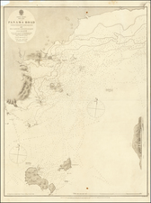
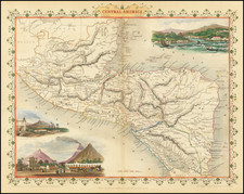
The Isthmus of Panama map, created by John Tallis in London in 1851, is a visually appealing cartographic work. It features full-color illustrations, including vignettes depicting the Fort at Chagres and Gold seekers traversing the cordilleras. The map also highlights proposed railways, indicating anticipated transportation developments in the region.
Engraved for R. Montgomery Martin's Illustrated Atlas of the World, Tallis's map showcases his talent as a decorative map maker. His maps are esteemed for their decorative elements, including vignettes portraying indigenous scenes and people, adding cultural and historical context to the cartographic representation.
The Isthmus of Panama map is a valuable contribution to the atlas, serving as a reliable source of geographical information. Its accurate depiction of the region and inclusion of proposed railways provide insights into the geographic and transportation landscape of the time.
John Tallis (1817-1876) was a British map publisher. Born in the Midlands, Tallis came to London in the 1840s. Tallis began his London career with a series of remarkable London street views. He began a partnership with a Frederick Tallis, possibly his brother, but their collaboration ended in 1849. For the Great Exhibition of 1851, Tallis published the Illustrated World Atlas, one of the last series of decorative world maps ever produced. The maps were engraved by John Rapkin, a skilled artisan. The maps were later reissued by the London Printing & Publishing Company, who left the Tallis imprint intact, thus ensuring his enduring fame. In 1858, he began publication of the popular Illustrated News of the World and National Portrait Gallery of Eminent Personages, selling it in 1861 (it ceased publication in 1863).