|
||

|

|
|

|
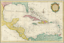
This 1891 map offers a comprehensive view of Mexico, Central American isthmuses, and the Caribbean, as conceived by C. Perron under the guidance of renowned geographer Élisée Reclus. Engraved by Erhard Fres and published by Hachette et Cie in Paris, it details the topography, cities, and maritime depths of the region at a scale of 1:12,000,000.
The map is distinguished by its stereographic meridian projection and precise delineation of physical geography, including color-coded elevations ranging from sea level up to peaks beyond 6,000 meters and ocean depths extending down to 8,000 meters. The classification of cities and towns by size, along with the demarcation of principal capitals and significant urban centers, offers an unusual glimpse into the demographic distribution and urban hierarchy of the time.
![[Mexico and Central America with Baja California inset, from Generalkarte von Nord America samt den Westindischen Inseln Versasst von Herrn. Pownall . . . MDCCLXXXVIII]](https://storage.googleapis.com/raremaps/img/small/95064.jpg)