This item has been sold, but you can enter your email address to be notified if another example becomes available.


|
||

|

|
|

|
Stock# 95941
Description
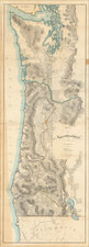
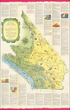
Early Regional Map of California
Scarce regional map of San Francisco, Alameda, San Mateo, Santa Cruz, Merced, San Benito and Part of Mariposa, Fresno, Tulare and Monterey Counties from Home Library and Supply Association's The Pacific Coast and the World.
Many small towns, railroads, rivers, mountains, Indian villages, railway stations, mines, and other details are shown. The Lick Observatory, finished in 1888, is shown on Mount Hamilton in Santa Clara County. Mills College is labeled in Oakland.
One of the few detailed separate maps of the region to appear in a 19th-century commercial atlas.
Condition Description
Minimal foxing, confined to margins.
![Map Showing the Summer Resorts on the Pacific Coast, adjacent to the lines of the Central and Southern Railroads. [California Tourist. Yosemite, The Big-Tree Groves Geysers, Monterey and other Popular Summer Resorts of Californa]](https://storage.googleapis.com/raremaps/img/small/41461.jpg)