|
||

|

|
|

|
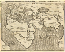
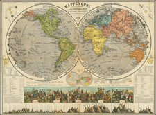
Striking large format map of the World on Mercator's projection, depicting the most recent discoveries throughout the world updated to 1784.
The map offers an intriguing snapshot of the world as it was understood by Europeans in the late 18th century. This map, updated to reflect discoveries made by 1784, paints a picture of a world in the midst of rapid exploration and revelation.
Between 1755 and 1784, a significant number of expeditions and voyages dramatically impacted the cartographical representation of the world. Captain James Cook, the British explorer, and navigator, made three voyages that revolutionized European understanding of the world. His voyages traversed much of the Pacific Ocean, and he mapped many areas more accurately than his predecessors. His encounters include Tahiti, the east coast of Australia, and numerous Pacific islands.
Previously unknown to Europeans, the Hawaiian archipelago, then called the Sandwich Islands in honor of the Earl of Sandwich, was one of Cook's major discoveries. Cook’s voyages clarified the geography of New Zealand. While earlier maps might have shown New Zealand based on Abel Tasman's earlier discoveries, Cook's more detailed exploration provides a fuller picture. The explorations along the Alaskan coastline and the Pacific Northwest were essential in understanding the contours and geography of what would become the United States' western frontier.
The inclusion of the South Sandwich Islands, an archipelago located in the southern Atlantic Ocean, east of Cape Horn was an acknowledgment of Cook's discovery. This southernmost landmass discovery was significant because it added to the geographic knowledge of the Southern Hemisphere.
Nicolas Bellin, a French hydrographer, played a critical role in charting areas during the mid-18th century. By 1784, his earlier editions required significant revisions and updates to accommodate new discoveries, emphasizing the rapid pace of geographical discoveries during this era. The inclusion of New Zealand on either side of the map reflects a cartographical decision to represent landmasses that straddle the 180th meridian, the antimeridian. This ensures that any country or landmass split by this line can be seen in its entirety on either side of the map.
In conclusion, the period between 1755 and 1784 saw a revolution in cartography, fueled by global explorations, most notably by Captain James Cook. This map from 1784 stands as a testament to this period of discovery, reflecting a world that was coming into sharper focus for European powers.