|
||

|

|
|

|
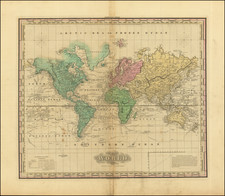
This beautiful world map by Daniel Stoopendaal stands as a remarkable specimen of Dutch Bible maps, distinguished by its decorative vignettes adapted from the Visscher-Berchem map of 1658. Featuring iconic scenes from Greek mythology and intriguing geographical inaccuracies such as California depicted as an island, this map embodies the artistic flamboyance and geographical understanding of its time.
In the mid-17th century, Dutch cartography was at its zenith, with Amsterdam becoming the center of the world map trade. This period, often referred to as the Golden Age of Dutch cartography, saw a fusion of art and geography that is beautifully represented in Stoopendaal's map. The map's margins are adorned with scenes from Greek mythology, including the abduction of Persephone, Zeus in his eagle-drawn chariot, Poseidon with his entourage, and Demeter receiving Earth's fruits. These embellishments lend the map a distinctive aesthetic character that transcends its functional role as a geographical representation.
Geographically, the "Orbis Terrarum Tabula Recens Emendata et in Lucem Edita" reflects the 17th-century understanding of the world. It showcases California as an island with a flat northern coastline labeled Nova Albion, a prevalent misconception in maps of that era. Other intriguing features include the small island near Alaska labeled Anian, a severely truncated northeastern coastline of Asia, and incomplete coastlines of northern and western Australia, Van Diemens Landt, and New Zealand. The possibility of New Guinea being attached to Australia is also suggested.
In the intersection of geography and astronomy, the map includes diagrams of the Copernican and Ptolemaic solar system theories, nestled between its cusps. These illustrations reflect the cosmological debates of the era, providing a visual summation of two competing theories of celestial mechanics.
The first state of the "Orbis Terrarum Tabula Recens Emendata et in Lucem Edita" with the imprint of A. Hogeboom Gelettert below the bottom neatline, this map stands as an invaluable artifact of Dutch Bible maps. It encapsulates the interplay of art, mythology, geography, and astronomy in a way that is both visually striking and historically significant.
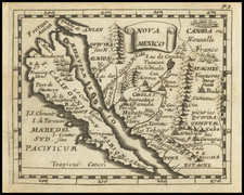
The popular misconception of California as an island can be found on European maps from the sixteenth through the eighteenth centuries. From its first portrayal on a printed map by Diego Gutiérrez, in 1562, California was shown as part of North America by mapmakers, including Gerardus Mercator and Abraham Ortelius. In the 1620s, however, it began to appear as an island in several sources. While most of these show the equivalent of the modern state of California separated from the continent, others, like a manuscript chart by Joao Teixeira Albernaz I (ca. 1632) now in the collection of the National Library of Brasil shows the entire western half of North Americas as an island.
The myth of California as an island was most likely the result of the travel account of Sebastian Vizcaino, who had been sent north up the shore of California in 1602. A Carmelite friar, Fray Antonio de la Ascensión, accompanied him. Ascension described the land as an island and around 1620 sketched maps to that effect. Normally, this information would have been reviewed and locked in the Spanish repository, the Casa de la Contratación. However, the manuscript maps were intercepted in the Atlantic by the Dutch, who took them to Amsterdam where they began to circulate. Ascensión also published descriptions of the insular geography in Juan Torquemada’s Monarquia Indiana (1613) (with the island details curtailed somewhat) and in his own Relación breve of ca. 1620.
The first known maps to show California as an island were on the title pages of Antonio de Herrera’s Descripción de las Indias Occidentales (1622) and Jacob le Maire's Spieghel Der Australische Navigatie (1622). Two early examples of larger maps are those by Abraham Goos (1624) and another by Henry Briggs, which was included in Samuel Purchas’ Hakluytus Posthumus or Purchas his Pilgrimes (1625). In addition to Briggs and Goos, prominent practitioners like Jan Jansson and Nicolas Sanson adopted the new island and the practice became commonplace. John Speed’s map (1626-7), based on Briggs’ work, is well known for being one of the first to depict an insular California.
The island of California became a fixture on mid- and late-seventeenth century maps. The island suggested possible links to the Northwest Passage, with rivers in the North American interior supposedly connecting to the sea between California and the mainland. Furthermore, Francis Drake had landed in northern California on his circumnavigation (1577-80) and an insular California suggested that Spanish power in the area could be questioned.
Not everyone was convinced, however. Father Eusebio Kino, after extensive travels in what is now California, Arizona, and northern Mexico concluded that the island was actually a peninsula and published a map refuting the claim (Paris, 1705). Another skeptic was Guillaume De L’Isle. In 1700, De L’Isle discussed “whether California is an Island or a part of the continent” with J. D. Cassini; the letter was published in 1715. After reviewing all the literature available to him in Paris, De L’Isle concluded that the evidence supporting an insular California was not trustworthy. He also cited more recent explorations by the Jesuits (including Kino) that disproved the island theory. Later, in his map of 1722 (Carte d’Amerique dressee pour l’usage du Roy), De L’Isle would abandon the island theory entirely.
Despite Kino’s and De L’Isle’s work, California as an island remained common on maps until the mid-eighteenth century. De L’Isle’s son-in-law, Philippe Buache, for example, remained an adherent of the island depiction for some time. Another believer was Herman Moll, who reported that California was unequivocally an island, for he had had sailors in his offices that claimed to have circumnavigated it. In the face of such skepticism, the King of Spain, Ferdinand VII, had to issue a decree in 1747 proclaiming California to be a peninsula connected to North America; the geographic chimera, no matter how appealing, was not to be suffered any longer, although a few final maps were printed with the lingering island.
![(Apian World Map) La Cosmographia de Pedro Apiano, corregida y añadida por Gemma Frisio ... El Sitio y Descripcion de las Indias y Mundo Nuevo, sacada de la Historia de Francisco Lopez de Gomara, y de la Cosmographia de Ieronymo Giraua Tarragonez [with map:] Mappa Mundi](https://storage.googleapis.com/raremaps/img/small/100234.jpg)
![[Early Photographic Facsimile in 24-Sheet of the Verrazano World Map]](https://storage.googleapis.com/raremaps/img/small/67041.jpg)